Nathia Gali Travel Guide: Weather, Hikes & How to Reach (2026)
A local guide to Pakistan's prettiest Galyat hill station: when to go, how to get there, the best forest hikes, and where to catch the snow.
Quick answer: Nathia Gali is a pine-forested hill station in Pakistan's Galyat region, sitting at around 2,500 metres between Murree and Abbottabad, roughly 75 km (a 2 to 3 hour drive) from Islamabad. Come from June to September for cool, green weather and hiking, or December to February for snow. The signature walk is Mushkpuri Top; the easiest is the Dunga Gali Pipeline Track.
If Murree feels too crowded and the Karakoram feels too far, Nathia Gali is the sweet spot. It is close enough to Islamabad for a weekend, high enough to stay cool through summer, and pretty enough that people keep coming back for the cedar forests, the mountain air and the fresh winter snow. This guide covers everything you need to plan the trip: the weather month by month, how to get there from Islamabad, Murree or Abbottabad, the best hikes and sights, where to stay, and when to catch the snow.
Where is Nathia Gali?
Nathia Gali (also spelled Nathiagali) is a hill station in the Galyat, a cluster of forested resort towns strung along the ridge between Murree and Abbottabad in Khyber Pakhtunkhwa. It sits at roughly 2,500 metres (about 8,200 feet), which is exactly why it stays cool when the plains are baking. Around it lie the other Galyat towns, Ayubia, Khaira Gali, Dunga Gali and Changla Gali, all within a short drive.
Wrapped in thick pine and cedar forest and backed by peaks that top 2,800 metres, Nathia Gali gets proper mountain weather: mild green summers and cold, snowy winters. It is part of Abbottabad District, and most of the walking around it falls inside Ayubia National Park.
Nathia Gali weather and the best time to visit
The short version: June to September is the most reliable window, with pleasant days between about 13°C and 20°C, clear skies and green forests. If you are chasing snow, come in January or February. Here is what to expect through the year.
| Season | Months | Weather | Good for |
|---|---|---|---|
| Spring | Apr–May | Cool, occasional rain, forests waking up | Fewer crowds, green scenery |
| Summer | Jun–Sep | Mild days 13–20°C, cool nights, clear spells | The classic visit: hiking, escaping the heat |
| Monsoon fringe | Jul–Aug | Warm but sudden rain, mist, some landslide risk on roads | Lush greenery (pack for rain) |
| Autumn | Oct–Nov | Crisp, cold nights, golden light | Quiet days, clear mountain views |
| Winter | Dec–Feb | Cold, often below 0°C, heavy snowfall | Snow and winter scenery (roads can close) |
Two practical notes. Weekends and public holidays in summer bring heavy domestic crowds and slow traffic on the Galyat road, so travel midweek if you can. And in winter, fresh snowfall occasionally shuts the higher stretches of road for a day or two, so keep your plans flexible and check conditions before you set off.
How to reach Nathia Gali
There is no airport or railway in the Galyat, so you arrive by road. Nathia Gali sits on the Murree–Abbottabad mountain road, and the two common approaches are from Islamabad through Murree, or from Abbottabad up through the Galyat.
| From | Distance | Driving time | Route notes |
|---|---|---|---|
| Islamabad | ~75–80 km | 2–3 hours | Via the Murree Expressway to Murree, then the Galyat road; the most scenic way in |
| Murree | ~38 km | about 1.5 hours | A winding forest road through Khaira Gali and Changla Gali |
| Abbottabad | ~60 km | about 2 hours | Up through the Galyat on the Nathiagali road |
| Lahore | ~360 km | 6–7 hours | Motorway to Islamabad, then continue as above |
A private car or hired taxi gives you the most freedom, especially for reaching the trailheads at Dunga Gali. Public transport runs to Murree and Abbottabad, and local vans and cabs continue to Nathia Gali from there, but services thin out in the evening and in bad weather. In winter, a vehicle with good tyres (and chains for heavy snow) is the difference between arriving and turning back.
The best things to do in Nathia Gali
Hike to Mushkpuri Top
The signature walk is Mushkpuri Top, at 2,800 metres (9,200 feet) the second-highest peak in the Galyat. The trail starts near Dunga Gali, a few minutes from Nathia Gali, and climbs about 4 km through the forest of Ayubia National Park to a broad summit meadow. Allow roughly two hours up and a little over an hour down. It is a moderate hike rather than a technical climb, and on a clear day the top opens up views across the Galyat toward Kashmir.
Walk the Dunga Gali Pipeline Track
For an easy, almost level walk, take the Pipeline Track from Dunga Gali to Ayubia. It follows a water pipeline laid in the 1930s to supply Murree, running flat through tall pines for about 4 km, roughly 40 to 50 minutes one way. It suits families and anyone not up for a climb, and the forest is full of birds and the occasional monkey. Walk out and back, or arrange a pickup at the Ayubia end.
Climb Miranjani, if you are fit
If Mushkpuri feels too gentle, Miranjani at 2,992 metres (9,816 feet) is the highest peak in the Galyat. The trail leaves from near Nathia Gali and makes a longer, steeper day out than Mushkpuri, rewarded with the widest views in the region. Start early and watch the sky, because the summit clouds over fast.
See St. Matthew's Church and the Governor's House
In the middle of town stands St. Matthew's Church, a small Anglican church built entirely of cedar wood in 1914 and cared for, for three generations, by a local Muslim family. Framed by spruce and dusted with snow in winter, it is the most photographed building in Nathia Gali. Nearby, the colonial-era Governor's House, once a summer retreat, sits behind its gardens and is worth a look from the road.
Explore Ayubia National Park
Much of the walking here falls inside Ayubia National Park, a belt of moist temperate forest that shelters leopards, monkeys, pheasants and plenty of birdlife. At Ayubia itself, a short drive away, a chairlift carries you up the ridge for an easy panoramic view, which is popular with families.
Where to stay in Nathia Gali
Nathia Gali has hotels for most budgets, from simple guesthouses to a handful of well-known mid-range and upper-range places with forest and valley views. Rooms are cheapest on midweek nights outside the summer and snow peaks, and dearest on summer weekends and during winter snowfall, when the town fills up. If Nathia Gali is fully booked, the neighbouring Galyat towns of Ayubia, Khaira Gali and Changla Gali, or Murree a little further on, make easy fallbacks. Book ahead for weekends and holidays, and confirm the room has heating if you are visiting in winter.
Snow in Nathia Gali: when to see it
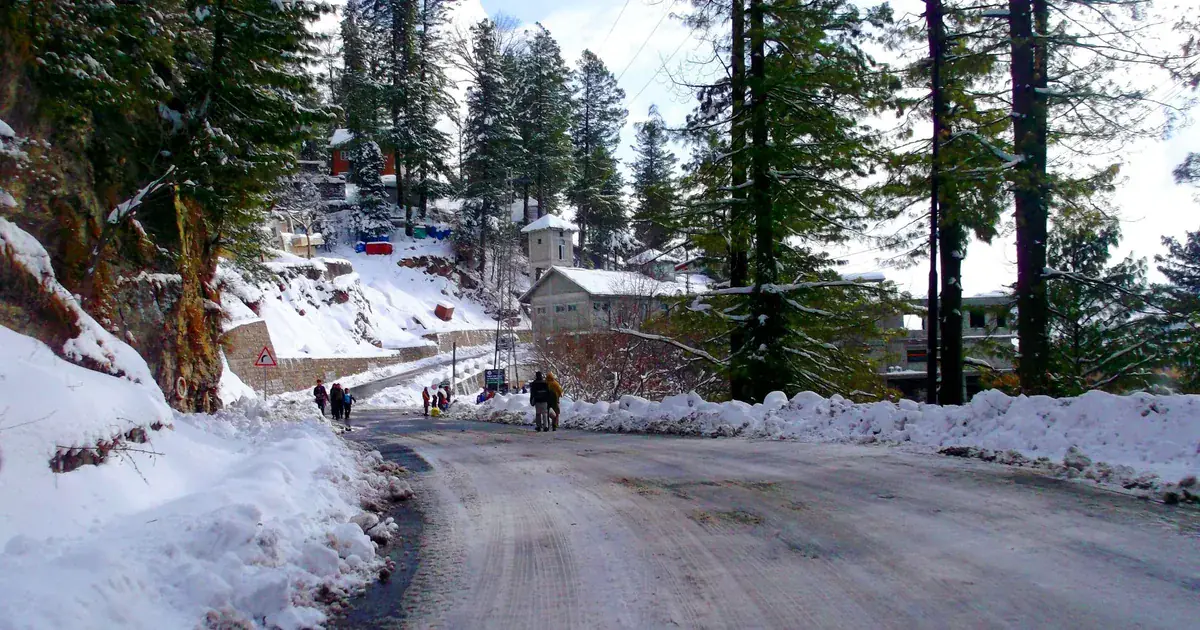
Snow is a big part of the appeal. The first flakes usually arrive in December, with the heaviest and most reliable snow through January and February, and patches often lingering into March at higher spots like Mushkpuri. Winter turns the church, the forest and the Governor's House into a postcard, but it comes with nights well below freezing, icy roads and the chance of a closure after a big fall. If snow is the goal, travel with warm layers, sensible footwear and a flexible plan, and set off early in the day.
Practical tips for visiting Nathia Gali
- Altitude: at 2,500 metres the air is thin and cool. It rarely causes altitude sickness, but you will feel the climb on the hikes, so pace yourself.
- Pack layers: even summer evenings turn cool, and a light rain jacket is wise in the monsoon months. In winter, bring a proper warm coat, gloves and grippy boots.
- Travel midweek: summer weekends and holidays are crowded; midweek is quieter and the roads move faster.
- Cash and fuel: carry enough cash and fill up in Murree or Abbottabad, as mountain ATMs and fuel pumps are limited.
- Respect the forest: Ayubia National Park is protected, so carry your litter out and keep to the marked tracks.
Nathia Gali sits at the gentler, greener end of Pakistan's mountains. If it leaves you wanting the bigger ranges, our team runs trips deep into the north; you can browse our guided tours across northern Pakistan, or, for help timing any trip, read our guide to the best time to visit Pakistan. And for a very different kind of mountain journey, our how to reach Fairy Meadows guide shows what getting to the high Karakoram actually involves.
Nathia Gali FAQ
Where is Nathia Gali?
Nathia Gali is in the Galyat region of Khyber Pakhtunkhwa, on the forested ridge between Murree and Abbottabad, about 75 km north of Islamabad.
How far is Nathia Gali from Islamabad?
Roughly 75 to 80 km, a 2 to 3 hour drive, usually taken via Murree and the Galyat road.
How high is Nathia Gali?
Around 2,500 metres (about 8,200 feet) above sea level, which keeps it cool through the summer.
What is the best time to visit Nathia Gali?
June to September for pleasant, green weather and hiking; December to February if you want snow.
When does it snow in Nathia Gali?
Snow usually starts in December, with the heaviest falls in January and February, sometimes lasting into March at higher elevations.
What is there to do in Nathia Gali?
Hike Mushkpuri Top, walk the easy Dunga Gali Pipeline Track, climb Miranjani, visit St. Matthew's Church and the Governor's House, and explore Ayubia National Park.
How do you get to Nathia Gali?
By road only. From Islamabad it is a 2 to 3 hour drive via Murree, about 1.5 hours from Murree, or about 2 hours from Abbottabad. There is no airport in the Galyat.
Ready for Your Next Adventure?
Join our community of explorers and discover the journey of a lifetime. Our expert team is ready to help you plan your perfect expedition.