Muztagh Ata — Father of Ice Mountains
The most accessible seven-thousander
Elevation
7,546m
Difficulty
Challenging
Duration
25–35 Days
Best Season
Jun–Aug
Muztagh Ata expedition: climbing and skiing the Father of Ice Mountains (7,546m)
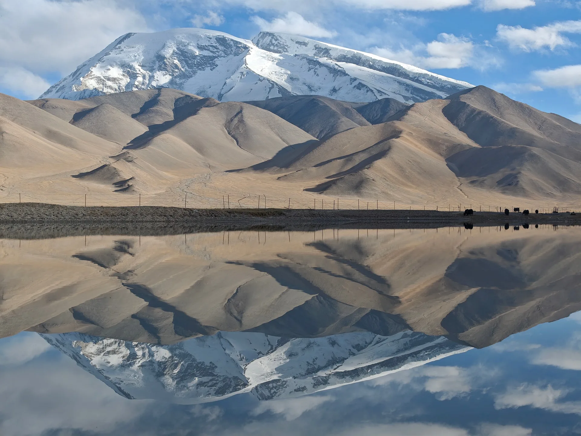
Muztagh Ata, the Father of Ice Mountains, is a 7,546-metre (24,757-foot) giant in the Chinese Pamir of Xinjiang, and the most accessible high peak of its size anywhere on Earth. Its enormous western flank rises in a single broad, gentle snow slope from the high desert near the Karakoram Highway, and that shape has made it the world's premier ski-mountaineering objective. For climbers based in Pakistan it is a natural cross-border expedition, reached overland up the Karakoram Highway through the Khunjerab Pass. A Muztagh Ata expedition is a 25-to-35-day trip that asks for fitness and patience with altitude far more than technical skill.
Where is Muztagh Ata? (China, not Pakistan)
Muztagh Ata stands in the eastern Pamir, in Xinjiang in far western China, close to the border with Tajikistan and near the Chinese end of the Karakoram Highway. The nearest town is Tashkurgan, and most expeditions stage through the old Silk Road city of Kashgar. The mountain rises above the high Pamir plateau near Lake Karakul, its base camp sitting at around 4,400 metres in open, rolling high-altitude desert grazed by Kyrgyz herders and their camels. Its name means Father of Ice Mountains in the local Uyghur language, and it is the second-highest of the peaks along the northern rim of the Tibetan Plateau.
Getting there from Pakistan: the Karakoram Highway and Khunjerab Pass
For climbers travelling from Pakistan, Muztagh Ata is reached overland on one of the great mountain roads of the world. The Karakoram Highway runs north from Gilgit and Hunza over the Khunjerab Pass at 4,700 metres, the highest paved border crossing on Earth, into China's Xinjiang. From the border it is a drive down to Tashkurgan and on toward Kashgar and the Muztagh Ata base camp near Karakul. This overland approach is part of the appeal, linking the Pakistani Karakoram with the Chinese Pamir along the old Silk Road. The crossing needs Chinese visas and permits arranged in advance, which we handle as part of the expedition.
Why Muztagh Ata is the world's great ski peak
Muztagh Ata is famous above all as a ski mountain. Its western slope is long, broad and consistently angled, with few crevasses and no technical climbing on the standard line, which makes it one of the very few 7,000-metre peaks that can be skied from the summit. In 1980 a team led by Ned Gillette made the first ski descent of any mountain over 7,500 metres here, and ever since, Muztagh Ata has been the goal for ski mountaineers who want a genuine high-altitude summit they can ride back down. Climbers without skis go up the same slopes on foot, and many parties carry skis purely for the descent.
The West Rib: the standard route
The standard route is the West Rib, the broad western shoulder climbed by the 1956 first-ascent expedition. From Base Camp at around 4,400 metres the route is split into three high camps: Camp 1 at roughly 5,500 metres, Camp 2 around 6,200 metres, and Camp 3 near 6,800 metres, with the summit day a long, steady plod up easy-angled snow to 7,546 metres. There is no steep ice, no rock and no real technical difficulty. The challenge is the altitude, the cold and the wind, and the sheer length of the days. Loads are often carried to Camp 1 by camel, a distinctive feature of climbing in the Pamir.
How hard is Muztagh Ata?
Muztagh Ata is widely considered the easiest 7,500-metre peak in the world, and one of the most popular first big-mountain objectives for climbers stepping up from 6,000-metre peaks or alpine summits. That said, easy is relative at this altitude. The summit is higher than anything in the Alps or North America, the weather and wind on the exposed western slope can be severe, and the long summit day defeats plenty of fit climbers. It is an excellent and attainable goal, but still a serious high-altitude expedition that rewards careful acclimatisation.
Best time to climb Muztagh Ata
The season runs through the Pamir summer, roughly June to August, with July often the most settled. The weather here is more continental and generally drier than the Karakoram to the south, but high wind is the defining hazard, and teams plan their summit bid around the calmest, clearest window. A full expedition of 25 to 35 days allows for the overland approach, acclimatisation rotations between the camps, and the wait for good weather.
Acclimatisation, camps and camels
Muztagh Ata is climbed in the usual stepped pattern of rotations: up to Camp 1 and back, then higher, sleeping progressively higher to let the body adapt before the summit push. Because the route is non-technical and the base camp already high, it makes an outstanding acclimatisation and training peak. It is climbed without supplemental oxygen, which most climbers will not need with good acclimatisation. Camels carry expedition loads from Base Camp up toward Camp 1 across the lower slopes, after which climbers ferry their own gear higher.
The dangers: altitude, weather and wind
The dangers on Muztagh Ata are those of altitude and weather rather than technical climbing. The western slope is high and exposed, and wind is the constant threat: it can rise quickly, drop the temperature sharply and force teams back from the summit. Altitude is the other hazard, and climbers who push too fast without proper acclimatisation risk altitude sickness on a mountain that otherwise looks straightforward. Whiteout navigation on the featureless upper slopes also demands care. As everywhere, conservative decisions and disciplined turnaround times keep climbers safe.
Permits and cost
Because Muztagh Ata is in China, it requires Chinese climbing permits and a Chinese liaison arrangement rather than a Pakistan mountaineering permit, along with Chinese visas and the Khunjerab border formalities. We arrange the permits, the border crossing and the in-China logistics as part of a fully supported expedition. A complete trip, covering the overland approach, permit and visa support, base camp and high camps, camel transport, climbing staff and full support, typically starts from around $16,000 per climber. Pricing here is indicative; we quote each expedition individually.
What it takes to climb Muztagh Ata
Muztagh Ata is an ideal first 7,000-metre peak for fit climbers with some mountain experience. We expect competence with crampons and ice axe and comfort on glaciated snow slopes, but no advanced technical climbing is required. Endurance is the key quality: the ability to keep moving through long days at altitude, and the patience to acclimatise properly rather than rushing. For ski mountaineers, solid off-piste and ski-touring skills at altitude are essential. With the right preparation, Muztagh Ata offers one of the most achievable routes to a genuine 7,000-metre summit, on foot or on skis.
Go With Guide Pakistan runs fully supported Muztagh Ata expeditions, handling the overland Karakoram Highway approach, the Khunjerab crossing, Chinese permits and visa support, base camp and high camps, camel transport and experienced high-altitude guiding. Whether you want to walk to the summit or ski back down from it, our team will help you plan the trip from Pakistan to the Father of Ice Mountains.
Climbing History
1947
Shipton and Tilman
Shipton and Tilman
Eric Shipton and Bill Tilman, two of the era's greatest mountain explorers, attempted Muztagh Ata in 1947 and were turned back high on the mountain, an early reconnaissance of what would become a classic route.
1956
First Ascent
First Ascent
A large joint Chinese-Soviet expedition made the first ascent via the West Rib, with Chinese climbers including Liu Lianman and Xu Jing and Soviet climbers including Evgeny Beletsky reaching the summit. The West Rib has been the standard route ever since.
1980
First Ski Descent
First Ski Descent
A team led by American Ned Gillette made the first ski descent of any peak over 7,500 metres, cementing Muztagh Ata's status as the world's premier high-altitude ski mountain.
Present
The Accessible Giant
The Accessible Giant
Muztagh Ata is now one of the most-climbed and most-skied 7,000-metre peaks on Earth, a favourite first big mountain and a magnet for ski mountaineers from around the world.
Recommended Reading
Through Asia
by Sven Hedin (1899)
Through Asia
by Sven Hedin (1899)
Mountains of Tartary
by Eric Shipton (1952)
Mountains of Tartary
by Eric Shipton (1952)
Frequently Asked Questions About the Muztagh Ata Expedition
Is Muztagh Ata in Pakistan or China?
Is Muztagh Ata in Pakistan or China?
Muztagh Ata is in China, in the eastern Pamir of Xinjiang, near Tashkurgan and the Chinese end of the Karakoram Highway. It is not in Pakistan, but it is a popular cross-border expedition for climbers based in Pakistan, who reach it overland up the Karakoram Highway through the Khunjerab Pass.
How do you get to Muztagh Ata from Pakistan?
How do you get to Muztagh Ata from Pakistan?
The expedition travels overland on the Karakoram Highway from Gilgit and Hunza over the Khunjerab Pass (4,700 m), the highest paved border crossing in the world, into China's Xinjiang, then on via Tashkurgan toward Kashgar and the base camp near Lake Karakul. The crossing needs Chinese visas and permits, which we arrange.
Can you really ski Muztagh Ata, and is it good for a first 7,000m peak?
Can you really ski Muztagh Ata, and is it good for a first 7,000m peak?
Yes on both counts. Its long, broad, gently angled western slope makes Muztagh Ata one of the few 7,000-metre peaks that can be skied from the summit, and it is one of the most popular first big mountains in the world thanks to its non-technical standard route. It is still a serious high-altitude climb that demands proper acclimatisation.
How hard is Muztagh Ata, and do you need oxygen?
How hard is Muztagh Ata, and do you need oxygen?
Muztagh Ata is widely regarded as the easiest 7,500-metre peak in the world. There is no steep ice or rock on the standard route, and it is climbed without supplemental oxygen. The real challenges are the altitude, the cold and the wind, and the length of the summit day, so fitness and good acclimatisation matter most.
When is the best time, and how long does the expedition take?
When is the best time, and how long does the expedition take?
The season is the Pamir summer, roughly June to August, with July often the most settled. A full expedition runs about 25 to 35 days, including the overland Karakoram Highway approach, acclimatisation rotations between camps, and waiting for a calm summit window.
What permits do you need, and how much does it cost?
What permits do you need, and how much does it cost?
Because it is in China, Muztagh Ata needs Chinese climbing permits, a Chinese liaison arrangement and Chinese visas, plus the Khunjerab border formalities, rather than a Pakistan permit. A fully supported expedition typically starts from around $16,000 per climber, covering permits and visa support, the overland approach, camps, camel transport and guiding. We quote each expedition individually.
What's Included
Not Included
Ready for Your Next Adventure?
Join our community of explorers and discover the journey of a lifetime. Our expert team is ready to help you plan your perfect expedition.