Basho Valley Skardu: Complete Travel Guide
How far it really is from Skardu, how high the valley actually runs, what the jeep track demands, and why no permit is needed.
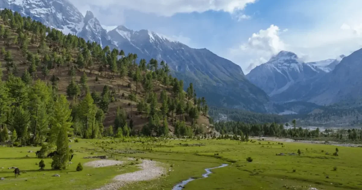
Basho Valley is a forested valley in the Roundu division of Skardu district, Gilgit-Baltistan, about 40 km from Skardu city. The valley runs from roughly 3,000 m to 3,600 m. Getting there takes around 30 to 40 minutes on tarmac to the Basho bridge, then 1.5 to 2 hours on a 10 km jeep track that only 4x4s can manage. No permit is required. The meadows are open from late May to early September, and almost everyone who stays overnight camps.
Basho is the valley people mean when they say Skardu has somewhere green. The floor is pine forest and grazing meadow with a river running through it, which is not what most of Baltistan looks like. You can be standing in it a couple of hours after breakfast in Skardu.
It is also a valley that published guides describe badly. Search for it and you will be told it is 40 km away and 45 km away, that it sits at 10,000 feet and at 11,800 feet, that the drive takes 1.5 hours and that it takes three. Those numbers are not really in conflict. They are measuring different things, and nobody says which. This guide sorts that out first, because the confusion is what makes people arrive with the wrong vehicle at the wrong time of year.
You will also see the name written Bashu Valley. Same place, and the spelling with the o is the one on the road signs.
Where Basho Valley is, and how far it actually is
The valley opens south off the Indus, in the Roundu division west of Skardu city. The turning is near Sultanabad village, which is why you will see the meadows themselves called Sultanabad Meadows. Both names describe the same destination: Basho is the valley, Sultanabad Meadows is the grassy basin at the top of the jeep track where the camps are.
The journey has two halves, and this is the detail that explains every contradictory number you have read:
| Leg | Distance | Time | Vehicle |
|---|---|---|---|
| Skardu city to the Basho bridge | ~30 km, sealed road | 30 to 40 minutes | Any car |
| Basho bridge to Sultanabad Meadows | ~10 km jeep track | 1.5 to 2 hours | 4x4 only |
| Total, door to meadow | ~40 km | 2 to 2.5 hours |
So the guides quoting "1.5 to 2 hours" are timing the jeep track alone. The ones saying three hours are counting a stop, or starting from a hotel out at Kachura. Forty kilometres is the figure that matches the road; the 45 km you will see on the official listing is close enough to be the same drive measured from a different point in town.
How high is Basho Valley?
Between about 3,000 m and 3,600 m, which is roughly 9,800 to 11,800 feet. That range is the answer, not a hedge.
The valley climbs about 2,000 feet along the jeep track alone. Quoting one number for it is like quoting one number for a staircase. The 8,800 to 10,000 feet that most travel guides give is too low for most of the valley; at best it describes the approach and the valley entrance. The 3,600 m on the Gilgit-Baltistan tourism portal is the top of the range, up where the basin closes. Both get copied around as though they were the whole valley.
The practical version: you camp at meadow level, and the altitude is low enough that acclimatisation is not a concern for a healthy visitor. This is nothing like the ground on our higher Karakoram treks, where height is the governing factor.
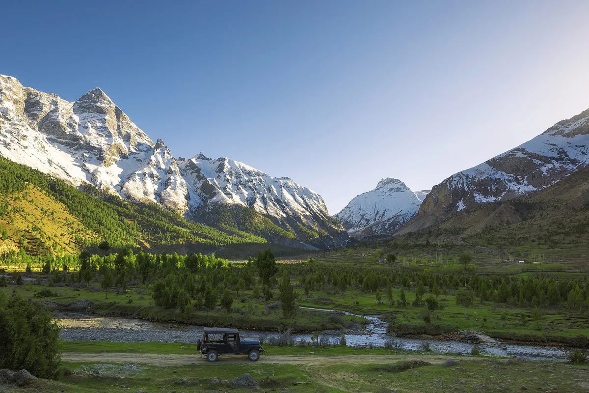
The Basho bridge and the jeep track
The tarmac ends at a bridge over the Basho river, and the bridge is the gate. It runs about 450 feet, carries a 1.5 tonne limit, and takes one vehicle at a time. Past it the surface turns to a cut shelf road: narrow, steep in sections, potholed, and carved into the mountainside with the drop on one side.
What that means in practice:
- A saloon car will not make it. Leave it at the bridge. This is the single most common mistake visitors make here.
- Hire a local 4x4. Expect roughly Rs 15,000 to 20,000 for the round trip, arranged in Skardu or at the bridge itself.
- Motorbikes need to be 150cc or bigger to hold the gradient.
- Go early. Drivers avoid the track in heavy rain and after fresh snow, and an afternoon start leaves no margin if you meet oncoming traffic on a narrow stretch.
The track passes Balti hamlets, wooden bridges over the side streams, and the occasional chai stall. It is a good ride if you are not driving it yourself.
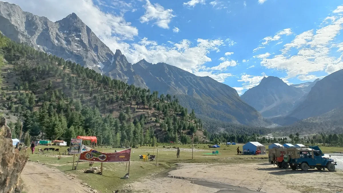
Camping at Sultanabad Meadows, and why "hotels in Basho" is the wrong search
There are no hotels in Basho. People search for them constantly and find nothing, because accommodation here is seasonal camps set up on the meadow by local operators, plus a small number of guest rooms in the villages below.
A pitched camp runs about Rs 1,000 to 5,000 per tent per night, or roughly Rs 4,000 to 12,000 for a group. That normally includes basic toilets, a kitchen serving Balti and Pakistani food, and a fire pit. Budget another Rs 2,000 to 3,500 per person for two days of meals.
What you do not get is hot water on demand or dependable electricity. And bring a proper sleeping bag: even in July the meadow drops to 5 to 8 °C overnight, so a bag rated to 0 °C is the sensible floor. Visitors who treat this as a warm-weather camping trip because the afternoon hit 24 °C have a miserable night.
If camping is not for you, Basho works perfectly well as a day trip from Skardu. Drive up in the morning, walk, eat at a camp kitchen, drive back before dark.
What there is to see
- Basho waterfall. The valley's set piece, fullest in June and July when the melt is running.
- Chocolate Rocks. Dark banded outcrops on the valley side, and the most photographed thing here after the meadow itself.
- Camel Rock. A 20 to 25 minute walk from the camping area, worth it for the view back down the valley more than for the rock.
- The three lakes. Small glacier-fed tarns above the meadows, none of them named on maps, reached on a two-day trek from the campsite. This is the one part of Basho that needs a guide and a plan rather than a jeep.
- The forest. Genuinely unusual for Baltistan, and the reason the valley feels different from Shigar or the Indus bank.
Basho sits inside snow leopard range, and markhor, ibex and Himalayan fox are all present. You are unlikely to see any of them on a weekend. Treat the wildlife lists in most guides as a description of the habitat rather than a promise.
Best time to visit Basho Valley
| Period | Conditions | Verdict |
|---|---|---|
| Late May | Track opening, meadows still coming through | Early but workable |
| June to August | Meadows green, days 15 to 25 °C, nights 5 to 8 °C | Best |
| Early September | Cooling, fewer camps, colour turning | Quietest good window |
| October | Camps closing, cold nights | Day trips |
| November to March | Snow on the track, winter lows to -25 °C | Not for overnight |
July and August are the reliable months and also the busy ones. If you want the meadow closer to empty, come in the first half of September and bring warmer kit. For how Basho fits the wider regional calendar, see our guide to the best time to visit Skardu.
Do you need a permit for Basho Valley?
No. Basho is in an open district. There is no No Objection Certificate to obtain and no trekking permit, which is a real difference from the Baltoro side of Baltistan, where K2 Base Camp and Concordia require both plus a per-person fee.
Foreign visitors should carry passport details for the checkposts on the Skardu road, and that is the whole of it. Every guide we checked leaves this question unanswered, which is why people assume a permit exists and lose days chasing one.
Going further: Banak La to Astore
Most visitors stop at the meadows. The valley also happens to be one end of a serious crossing: Banak La, at 4,964 m, links Basho over to Shigar Thang and down into Astore, with Nanga Parbat in view from the top.
This is a different proposition from a camping weekend. It is a multi-day glaciated crossing needing rope, crampons and an ice axe, and it should only be attempted with a guide who knows the route. We mention it because it is the reason a trekker, as opposed to a weekender, would care about Basho at all, and because it appears in almost none of the guides written about this valley.
What to bring, and what is not there
- No ATM and no fuel station beyond Skardu. Draw cash and fill up before you leave the city.
- Almost no mobile signal. SCOM works intermittently. Nothing else does.
- Nearest medical care is Skardu. Bring your own first aid.
- Sleeping bag rated to 0 °C, a warm layer for the evening, and sun protection for the middle of the day.
Fitting Basho into a Skardu trip
Basho is a one to two night addition, not a trip in itself. It pairs naturally with the Deosai plateau, which starts on the other side of Skardu and is the region's other great grassland; our Deosai National Park guide covers that side. Soq and Chunda valleys are nearby and quieter still.
We build Basho into custom itineraries as the green interval between the lakes around Skardu and the harder ground further east. If you want it arranged with the jeep, the camp and a Balti guide already sorted, start with our Skardu tours.
Frequently asked questions
How far is Basho Valley from Skardu?
Basho Valley is about 40 km from Skardu, which takes 2 to 2.5 hours in total. The first 30 km to the Basho bridge is sealed road and takes 30 to 40 minutes in any car. The last 10 km is a jeep track that takes 1.5 to 2 hours and needs a 4x4. That split explains the conflicting numbers you will find online. Guides quoting 1.5 to 2 hours are timing the jeep track alone, and the ones saying three hours are counting a stop or starting from a hotel out at Kachura. The 45 km on the official listing is close enough to be the same drive measured from a different point in town. The valley opens south off the Indus in the Roundu division, west of Skardu city, with the turning near Sultanabad village. Go early in the day, so you are not meeting oncoming traffic on the narrow track late in the afternoon.
Do you need a permit for Basho Valley?
No. Basho is in an open district, so there is no No Objection Certificate and no trekking permit. Foreign visitors need passport details for the checkposts on the Skardu road, and that is the whole of it. This is a real difference from the Baltoro side of Baltistan, where K2 Base Camp and Concordia need both a permit and a No Objection Certificate, plus a per-person fee. Many guides leave the question unanswered, which is why people assume a permit exists and lose days chasing one. Keep a copy of your passport handy and expect your details to be noted at a checkpost or two on the way out of Skardu. The one part of Basho that needs more than a jeep is the onward crossing over Banak La, at 4,964 m, to Astore. That is a glaciated multi-day route needing rope, crampons and an ice axe, and it should only be done with a guide who knows it.
Can you drive a normal car to Basho Valley?
Only as far as the Basho bridge. Past the bridge the track is a narrow, steep, potholed shelf road and needs a 4x4. Motorbikes of 150cc or more manage it. A round-trip jeep hire runs roughly Rs 15,000 to 20,000, arranged in Skardu or at the bridge itself. The first 30 km from Skardu is sealed and any car will do it in 30 to 40 minutes. The bridge is the gate. It runs about 450 feet, carries a 1.5 tonne limit and takes one vehicle at a time. Beyond it the road is cut into the mountainside with a drop on one side, and a saloon car will not make it, which is the most common mistake visitors make here. Leave the car at the bridge and switch to a local jeep. Drivers avoid the track in heavy rain and after fresh snow, so an early start leaves margin if conditions change.
How high is Basho Valley?
Basho Valley runs from about 3,000 m to 3,600 m, or roughly 9,800 to 11,800 feet. The jeep track alone climbs around 2,000 feet, which is why published figures for Basho disagree: they are describing different points in the same valley. That range is the answer rather than a hedge. The 8,800 to 10,000 feet that most travel guides give is too low for most of the valley; at best it describes the approach and the valley entrance. The 3,600 m on the Gilgit-Baltistan tourism portal is the top of the range, up where the basin closes. Both get copied around as though they were the whole valley. In practice you camp at meadow level, and the altitude is low enough that acclimatisation is not a concern for a healthy visitor. Height does matter for the temperature, though. Nights on the meadow drop to 5 to 8 °C even in July, so pack for cold evenings however warm the afternoon feels.
What is the best time to visit Basho Valley?
June to August is the best time to visit Basho Valley, with early September as the quietest good window. Days run 15 to 25 °C and nights drop to 5 to 8 °C even in midsummer. From November to March the track carries snow and the valley is a day trip at most. The season starts in late May, when the track opens and the meadows are still coming through, which is early but workable. July and August are the most reliable months and also the busiest, and the Basho waterfall is fullest in June and July while the melt is running. In early September the camps thin out and the colour starts turning, so bring warmer kit. By October the camps are closing and the nights are cold, so it suits day trips only. In winter, lows reach -25 °C and the valley is not for overnight stays.
Are there hotels in Basho Valley?
No. Accommodation is seasonal tented camps on the meadows at roughly Rs 1,000 to 5,000 per tent per night, plus a few village guest rooms lower down. Many visitors stay in Skardu and come up for the day. A camp for a group runs roughly Rs 4,000 to 12,000, and that normally includes basic toilets, a kitchen serving Balti and Pakistani food, and a fire pit. Budget another Rs 2,000 to 3,500 per person for two days of meals. What you will not get is hot water on demand or dependable electricity, and mobile signal is almost nil, with only SCOM working on and off. Bring a sleeping bag rated to 0 °C, because the meadow is cold at night even in July. There is no ATM or fuel station beyond Skardu, so draw cash and fill up before you leave the city. We can arrange the jeep, camp and a Balti guide together.
Is Basho Valley the same as Sultanabad Meadows?
Effectively yes. Basho is the valley, and Sultanabad Meadows is the grassy basin at the top of the jeep track, named after Sultanabad village below. Most camps and photographs described as Basho are on those meadows. The valley opens south off the Indus in the Roundu division west of Skardu, and the turning off the main road is near Sultanabad village, which is how the meadows got the name. When people book a camp in Basho, they are almost always booking a tent at Sultanabad. The meadows sit around 10 km and 1.5 to 2 hours up the jeep track from the Basho bridge. From the camping area, Camel Rock is a 20 to 25 minute walk, and the three small glacier-fed lakes above are a two-day trek that needs a guide. You will also see the valley spelled Bashu. Same place, though the road signs use the spelling with an o.
Ready for Your Next Adventure?
Join our community of explorers and discover the journey of a lifetime. Our expert team is ready to help you plan your perfect expedition.