Baskochi Meadows Trek: Hunza's Best View in an Hour
A short, steep hike above Attabad Lake that trades under an hour of climbing for one of the biggest views in Upper Hunza.
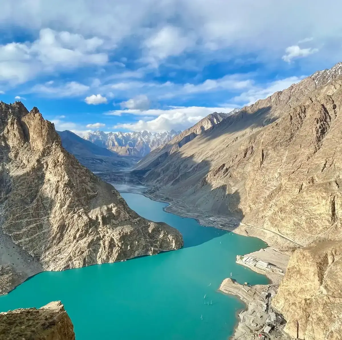
Some views in Hunza cost you a week of trekking and a base camp. Baskochi is not one of them. From the roadside between two tunnels on the Karakoram Highway, a stiff little climb of under an hour lifts you onto a shoulder of meadow high above Attabad Lake, and the whole upper valley opens up at once. It is, hands down, the best reward-to-effort view we send day-trippers to in the Hunza region.
This guide covers what the walk is actually like, how to reach the trailhead from Karimabad, when to go, and the one fact almost every other page online gets wrong.
Baskochi at a glance
| Detail | What to expect |
|---|---|
| Location | Above Attabad Lake, near Shishkat, Upper Hunza (Gojal), Gilgit-Baltistan |
| Trailhead | Roadside parking between KKH Tunnel 2 and Tunnel 3 |
| Distance | ~3 km round trip (about 1.5 km each way) |
| Time | 45 min to 1.5 hrs up; a little less coming down |
| Difficulty | Easy to moderate. Short but almost all uphill |
| Elevation | A few hundred metres above the lake (~2,400 m). See the altitude note below |
| Best time | June to early October |
| Permit | None. A small local ticket (~PKR 500) may be collected |
| Guide | Optional. Handy on your first visit |
Where is Baskochi Meadows?
Baskochi sits on the western slopes above Attabad Lake, roughly 30 km (about an hour's drive) north of Karimabad in the Gojal part of Upper Hunza. Attabad Lake itself was formed by a landslide that dammed the Hunza River in 2010, and the Karakoram Highway now threads past it through a series of tunnels. The Baskochi trailhead is hidden in plain sight between the second and third of those tunnels, near the village of Shishkat.
That location is the whole point. You are standing above one of the most photographed lakes in Pakistan, with the Passu Cones, Passu Sar and Shispare lined up down-valley, and Rakaposhi and Ultar Sar visible on a clear day. Very few viewpoints in the country pack this much scenery into so short a walk.
What the walk is actually like
Do not let the short distance fool you into thinking it is flat. From the road the trail goes up almost the entire way, first over loose scree and rock, then onto open grazing meadow crossed by a couple of small streams. In summer the upper slopes are dotted with wildflowers and the odd shepherd's animals; you may spot marmots, and ibex range higher up.
Most people reach the top in 45 minutes to an hour at a steady pace. Take it slower and budget 90 minutes. It is the kind of climb that gets your lungs working but never needs your hands, and there is no exposure or scrambling. Wear proper shoes, though. The lower section is loose and can be slippery on the way down.
The view from the top
The payoff is a wide grassy shoulder, Baskochi Top, looking straight down onto the turquoise sweep of Attabad Lake. Boats leave thin white wakes far below, the KKH curls along the far shore, and the jagged spires of the Passu Cones close off the horizon. It is the classic Upper Hunza panorama, and it is even better in the soft light of early morning or late afternoon.
How to reach the Baskochi trailhead
Almost everyone starts from Karimabad, the main tourist base in central Hunza. From there:
- Drive north on the KKH toward Attabad Lake (~30 km, roughly one hour). You can self-drive, hire a car, take a local van, or rent a motorbike.
- Pass through the tunnels. The road runs through several tunnels along the lake. The trailhead is at the roadside parking between Tunnel 2 and Tunnel 3, near Shishkat.
- Park and start walking. The path climbs from the road up the slope on your left as you look at the lake. There is no ticket booth to speak of, though a local may collect a small fee.
- Return the same way and drive back to Karimabad for the night, or combine it with a boat ride on Attabad Lake before you leave.
There is no public accommodation at the trailhead itself. Base yourself in Karimabad, or camp at one of the sites down by the lake. For the bigger picture of where Hunza fits into a northern trip, our Northern Pakistan travel guide maps out the whole region.
Best time to visit Baskochi Meadows
The trek is a summer and autumn outing. From roughly June to early October the trail is clear and the meadow is green or gold. Outside that window snow covers the upper slopes and the drive itself gets harder.
| Season | What it's like |
|---|---|
| Jun to Aug | Green meadow, wildflowers, warmest days. Peak tourist season in Hunza |
| Late Sep to Oct | Autumn gold on the slopes and poplars below. Crisp air, superb light, our favourite window |
| Nov to May | Snow on the upper trail, cold and often not worth it. Best skipped |
A note on the altitude (the fact most pages get wrong)
You will see several websites claim Baskochi Top sits at 3,900 m (12,795 ft). Treat that with suspicion. Attabad Lake sits at roughly 2,400 m, and a 45-minute climb simply cannot gain 1,500 vertical metres. Realistically the viewpoint is only a few hundred metres above the lake, somewhere in the 2,600 to 2,900 m range. We flag this because the inflated number gets copied from blog to blog, and it makes an easy hilltop walk sound like a serious high-altitude trek. It is not. If anything, that is good news: no acclimatisation worries here.
Is the Baskochi trek worth it?
For most travellers, yes, easily. If you have half a spare day in Hunza and can manage an hour of uphill walking, the return on effort is hard to beat. It suits families with active older kids, first-time trekkers, and anyone who wants a genuine Karakoram viewpoint without committing to a multi-day route.
If you are after something longer and higher, the Patundas Meadows trek climbs to a far loftier alpine shelf above the same Passu and Batura glaciers, and pairs naturally with Baskochi on a longer Hunza itinerary.
What to bring
- Sturdy shoes or hiking boots. The lower trail is loose underfoot.
- Water and a snack. There are no shops on the trail.
- Sun protection. The slope is open with little shade.
- A light layer. The top is breezy even on warm days.
- Your camera. Obviously.
Mobile coverage is patchy once you leave the road, so download any maps you need in advance. A useful GPS reference for the exact line is the community-mapped Baskochi trail on Wikiloc.
Pair it with the rest of Hunza
Baskochi works best as one stop on a wider Hunza trip rather than a destination on its own. In a few days you can add Baltit and Altit forts, the Eagle's Nest viewpoint, a boat ride on Attabad Lake, and a run up to the Khunjerab Pass. Our guide to the best places to visit in Hunza Valley lays out the highlights, and the Hunza Valley tour packages post shows how it all fits into a trip.
When you are ready to plan, our Hunza Valley tours put a local guide and the driving logistics in place, so viewpoints like Baskochi slot into your days without the guesswork.
Frequently asked questions
How long is the Baskochi Meadows trek?
It is about 3 km round trip. Most walkers reach the top in 45 minutes to an hour, or up to 90 minutes at a gentle pace, with a slightly quicker descent.
How hard is the Baskochi trek?
Easy to moderate. It is short but climbs almost the whole way over loose ground, so it gets your lungs going. There is no scrambling or exposure, and anyone comfortable walking uphill for an hour can do it.
What is the altitude of Baskochi Top?
Lower than the internet says. Attabad Lake sits at about 2,400 m and the viewpoint is only a few hundred metres above it, so roughly 2,600 to 2,900 m. The widely quoted "3,900 m" figure is almost certainly wrong for a 45-minute climb.
Do you need a permit or a guide for Baskochi?
No permit is required. A small local ticket of around PKR 500 may be collected. A guide is optional but helpful on a first visit, both for the route and for the drive through the tunnels.
When is the best time to visit Baskochi Meadows?
June to early October. Summer brings green meadows and wildflowers, while late September and October add autumn colour and the clearest light. From November to May the upper trail is usually under snow.
How do you get to the Baskochi trailhead from Karimabad?
Drive about 30 km (one hour) north on the Karakoram Highway toward Attabad Lake. The trail starts at the roadside parking between Tunnel 2 and Tunnel 3, near Shishkat village. Cars, vans, and motorbikes all make the trip.
Is the Baskochi Meadows trek worth it?
Yes. It is one of the highest reward-to-effort viewpoints in Hunza: a full panorama of Attabad Lake and the Passu Cones for under an hour of walking, with no permit and no serious altitude.
Ready for Your Next Adventure?
Join our community of explorers and discover the journey of a lifetime. Our expert team is ready to help you plan your perfect expedition.