Patundas Meadows Trek: How Hard, How High
The Hunza trek that gets quoted at five different altitudes. What those numbers actually mean, what it costs, and how hard the Passu Glacier crossing really is.
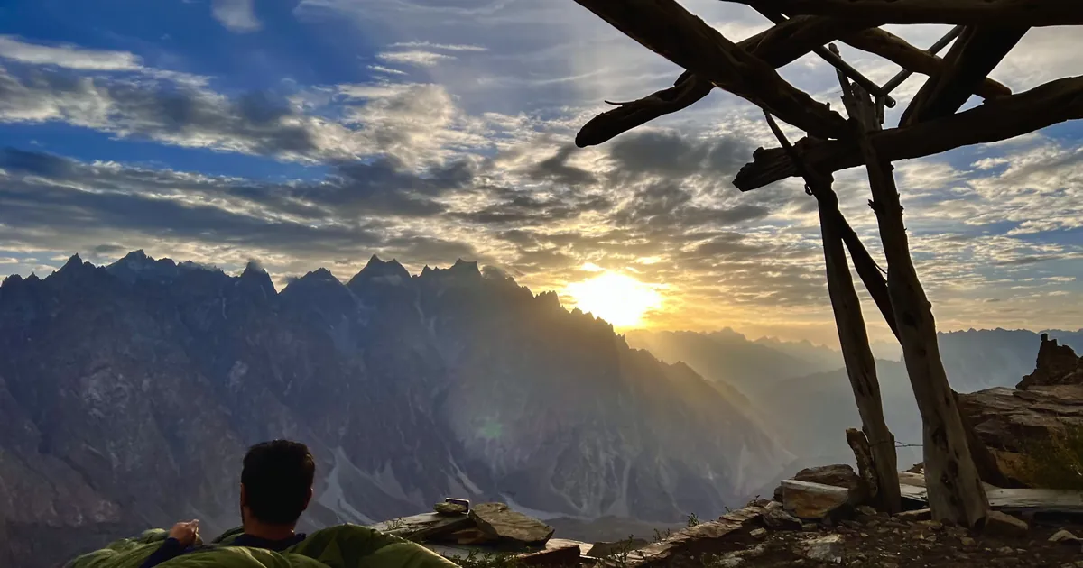
Look up the Patundas trek and you will find it listed at five different altitudes. One site says 4,200 m. Another says 4,300 m. A tour operator says 4,575 m. A trail database says 4,700 m. A trip report mentions 4,800 m. Distances range from 22 km to 29 km, and the trek is variously two days, three days, or a very long single push.
None of those numbers is invented. They just describe different points on the same hill, and nobody bothers to say which. Here is what the figures actually mean, followed by the parts of the trek that decide whether you enjoy it or endure it.
The altitude question, settled
Patundas is not a summit. It is a broad, rolling alpine shelf slung between the Passu Glacier to the south and the Batura Glacier to the north, and it rises steadily from the lip where you first arrive to the ridgeline at its back. Where you stop determines the number you go home with.
| Figure you will see quoted | What it actually refers to |
|---|---|
| ~4,200 m | The meadow itself, where the stone shelters and the camping ground are. This is the figure most people mean by "Patundas". |
| ~4,300 m | The upper camping spots, a little way above the first flat ground. |
| ~4,575 m | The high point of the ridge behind the meadow, and the number our guides use. |
| 4,700 to 4,800 m | Points further along that ridge, reached as a side walk from camp rather than as part of the main route. |
The same logic explains the distance spread. Borith Lake to the meadow and back is around 24 km. Add the ridge walk and a night at the top camp and you are closer to 30 km. If a figure looks high to you, it almost certainly includes the ridge.
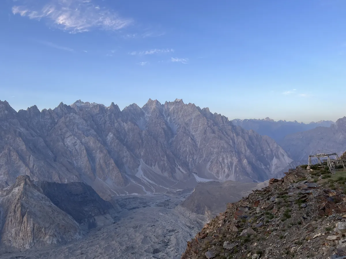
How hard is the Patundas trek?
Moderate is the honest grade, and it is a fair one. There is no rope work beyond what your guide rigs on the ice, no exposure that would trouble anyone comfortable on a hill path, and no scrambling. What the grade hides is that the effort arrives in three distinct lumps, and each one catches a different kind of person out.
The climb to Passugar. From Borith Lake at roughly 2,600 m the trail goes up a dry, shadeless ridge to the shepherd pasture at Passugar, around 3,200 m. Three to four hours, no water on the way, and it faces the sun. Most people find this the least enjoyable stretch of the whole trek, and it is the one that punishes a late start.
The glacier. Three to four hours of picking a line across bare ice and rubble. It is not strenuous in the way a climb is, but it demands constant attention and it is slow.
The 800 m to the meadow. Day two starts with a sustained climb from Luzdhar camp at about 3,400 m to the plateau. Three to four hours, on ground that changes from loose rock to grass as you gain height. This is where altitude starts to be felt by people who have come up the valley quickly.
A useful benchmark: if you can walk uphill for four hours carrying a daypack, on consecutive days, you will be fine. If your longest recent walk was on the flat, you will finish it but you will not enjoy day two.
The Passu Glacier crossing
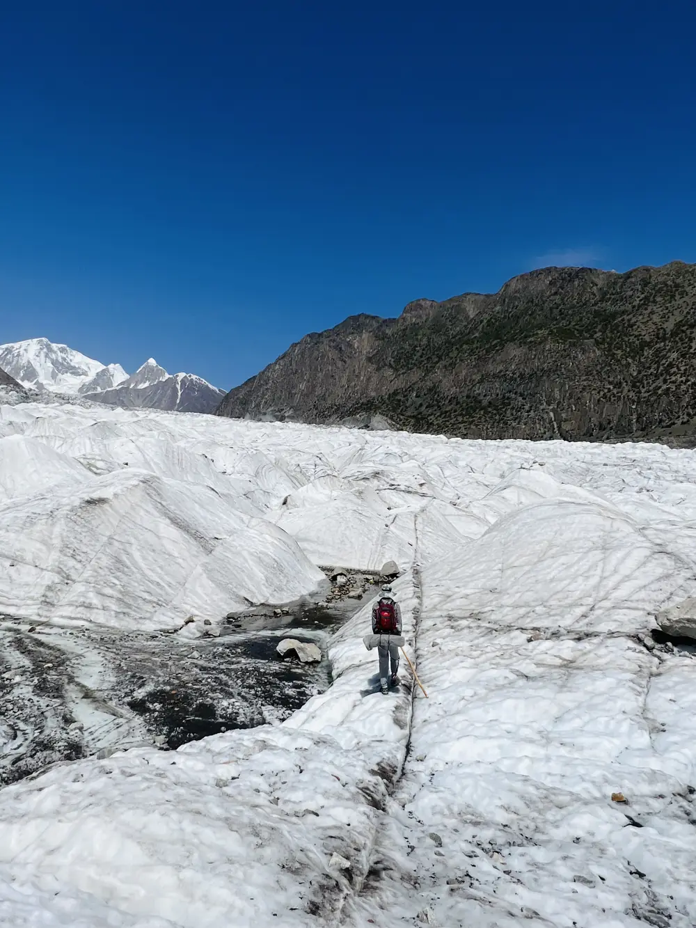
This is the part people ask about, and it deserves the attention. The Passu Glacier surface is crevasses, ice pillars, meltwater channels and loose boulders, and the working route across it changes as the ice melts and shifts. It can change inside a single day. Guides from Gojal walk it often enough to know where the ice is holding that week, and some carry a short ladder for crevasses that have opened up since the last trip.
In practice you are roped for the sections at each end, where the ice is broken and the crevasses are real. The middle is rougher underfoot but more stable, and you spend most of it walking on rock and compacted ice rather than anything that needs technique. It takes three to four hours.
This is also why a GPS track someone recorded last season is worse than useless here. The line it follows has since melted.
Altitude, and the mistake most people make
The trek itself has a sensible altitude profile. You sleep at 2,600 m, then at 3,400 m, and you visit 4,200 m as a day trip before dropping all the way back down. That is a gentle enough progression that altitude sickness is uncommon among people who arrive already adjusted.
The problem is how people get there. Fly Islamabad to Gilgit and you go from roughly 500 m to 1,500 m in an hour, then drive three to four hours further up the valley. Start trekking the next morning and you are asking your body to handle 2,600 m to 4,200 m on almost no adaptation.
Give it two or three nights in Hunza first. Karimabad, Gulmit or Borith Lake all work, and a night at Borith immediately before the trek is worth arranging anyway because it puts you at the trailhead for an early start. Headache, nausea, breathlessness at rest and trouble sleeping are the signals to take seriously; the NHS guidance on altitude sickness is a sound summary. On this route the remedy is simple, because down is never far away.
How much does the Patundas trek cost?
Costs split cleanly into two models, and the gap between them is large enough that it is worth understanding what the money buys.
| Hire a guide yourself | Fully supported trek | |
|---|---|---|
| Rough cost | From about $60 per person for a small group, plus transport | Around $350 per person |
| You get | A guide and the glacier crossing | Guide, porters, tents, all meals, glacier ropes, transport from Gilgit or Karimabad, fees |
| You carry | Tent, sleeping bag, mat, stove, all food and water for two days | A daypack |
| Suits | Experienced independent trekkers with their own kit already in Pakistan | Anyone flying in without camping gear, or short on time |
The cheaper number is real and it is what independent trekkers pay, but it assumes you have a tent, a bag rated to below freezing, a stove and two days of food with you in Gojal. Renting that locally is possible and inconsistent. Our own two-day Patundas Meadows trek sits at the other end: Wakhi guides from Gojal who cross the Passu Glacier regularly, a porter team, and everything from the ropes to the food included.
Do you need a permit for Patundas?
No. Patundas is in an open zone. Hunza and Gojal, including Borith Lake, Passu, Gulmit and the Karakoram Highway corridor, are open to foreign visitors on an ordinary Pakistani tourist visa with no No Objection Certificate and no trekking permit to arrange in advance.
Permits apply to restricted zones near the Line of Control and certain border valleys, and to climbing peaks above 6,500 m. Patundas is neither. Nobody will ask you for paperwork on this trail, and any operator quoting you a permit fee for it should be asked what the fee is for.
When to go
June to September, with July and August the most reliable. Two things narrow that window further depending on what you want.
- The meadow flowers in late June and early July, when it fills with edelweiss, primulas, buttercups and gentians.
- The glacier route is at its best in mid-summer, once guides have had several weeks of traffic to establish and maintain a line across the ice.
- Late September still works, but the weather turns less predictable. Nights at Luzdhar are cold even in July.
Whatever month you pick, start early. Cloud builds over the Karakoram through the afternoon, and the difference between a 6am arrival at the meadow and a 1pm one is often the difference between eighteen visible peaks and none.
What it looks like when the weather turns
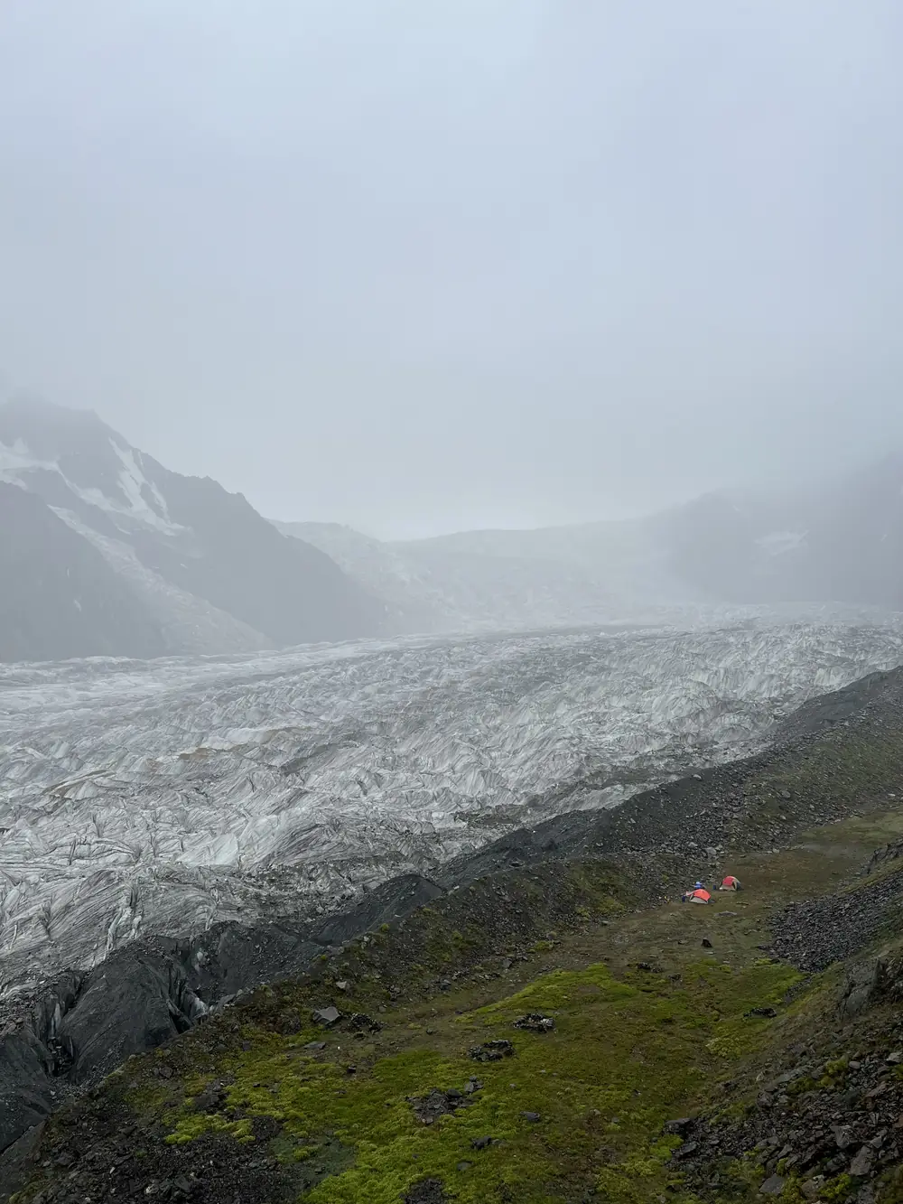
Almost every photograph of Patundas online was taken on a clear morning, which gives a misleading impression of what you are signing up for. Cloud settles on the plateau regularly, and when it does you get a green meadow, a grey wall, and no peaks at all.
This matters for planning rather than for safety. The glacier crossing is unpleasant in poor visibility but the route is worked out by touch and memory as much as by sight, and the ground is the same ground. What you lose is the reason you came. If you only get one attempt at the view and the forecast is poor, hold a spare day rather than walking up into cloud.
It also explains the gear list. A waterproof shell, a bag rated to around -5C, and dry spare layers are not optional extras at 4,200 m in weather like this, and there are no shelters, shops or tea houses anywhere on the route.
Getting to the trailhead
Borith Lake is the start, a glacial lake at around 2,600 m sitting between Gulmit and Passu, a short climb off the Karakoram Highway. From Gilgit it is three to four hours by road. From Karimabad it is closer to an hour and a half.
Gilgit is reachable by a one-hour flight from Islamabad, which is scenic and frequently cancelled for weather, or by fourteen to sixteen hours of driving up the Karakoram Highway. Most people going to Patundas are already in Hunza for other reasons, which is the sensible way to do it.
There are guest houses and basic camping at Borith Lake itself. Staying the night before is worth it twice over: you acclimatise a little, and you can be walking at first light instead of driving at it. If two days on the hill is more than you want, Baskochi Meadows gives you a comparable Hunza panorama for about ninety minutes of climbing.
Frequently asked questions
How high is Patundas Meadows?
The meadow sits at about 4,200 m. The ridge behind it reaches roughly 4,575 m, and points further along that ridge are quoted between 4,700 m and 4,800 m. Figures above 4,300 m always refer to the ridge, not to the meadow where you camp.
How many days do you need for the Patundas trek?
Two days is the standard: Borith Lake to Luzdhar camp on day one including the Passu Glacier crossing, then up to the meadow and back down to Borith on day two. Three days lets you sleep at the top camp and walk the ridge properly, which is the version most photographers choose.
Do you need a permit for the Patundas trek?
No. Patundas is in an open zone in Gojal, Upper Hunza. A standard Pakistani tourist visa is enough, and no No Objection Certificate or trekking permit is required.
Can you do Patundas in one day?
It is physically possible and we do not recommend it. Around 1,600 m of ascent, a glacier crossing in each direction and the full distance back leaves almost no time at the meadow and a real chance of finishing in the dark.
Is the Passu Glacier crossing dangerous?
It is the most serious part of the trek and it is routinely done by fit trekkers with no mountaineering background. The risk comes from the route changing week to week rather than from the terrain being technical. That is the whole argument for hiring a guide from Gojal who has been on the ice recently.
What is the best month for the Patundas trek?
July and August offer the most settled weather and the best-maintained glacier route. Late June and early July are best if you want the meadow in flower.
Is there mobile signal on the trek?
Intermittently around Borith Lake and Passugar, and none once you cross the glacier. Carry a power bank and leave your itinerary with someone before you start.
Ready for Your Next Adventure?
Join our community of explorers and discover the journey of a lifetime. Our expert team is ready to help you plan your perfect expedition.