Rakaposhi & Diran Base Camp Trek: Itinerary, Cost & Best Time
One trailhead, two base camps: the walk from Minapin to Rakaposhi Base Camp, the glacier crossing to Diran, and the real altitudes, season and costs.
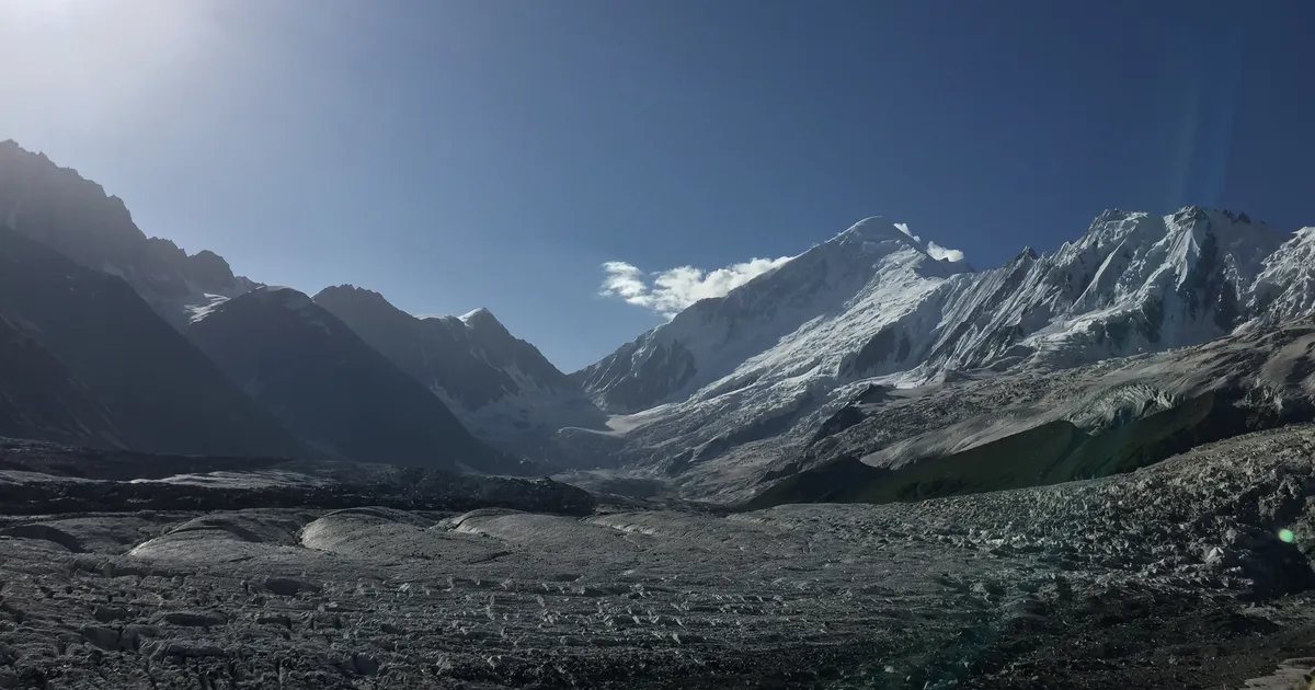
Rakaposhi is the mountain everyone photographs from the Karakoram Highway and almost nobody walks up to. From the roadside village of Minapin you can be at its foot in a day and a half, camped on a meadow where a 7,788 m wall of ice fills the sky and the Minapin Glacier creaks below your tent. Diran is the other peak in that view, the smooth snow pyramid across the ice, and its base camp is a half-day further on for anyone willing to cross the glacier.
Most guides treat these as one vague "Rakaposhi Diran trek". They are two different objectives with two different levels of difficulty. This guide covers both, starting with the classic three-day walk to Rakaposhi Base Camp and then the five-day version that crosses the ice to Diran.
Rakaposhi and Diran Base Camp at a glance
| Detail | Rakaposhi Base Camp | Diran Base Camp (Minapin side) |
|---|---|---|
| Camp | Tagaphari meadow | Moraine below Diran, east side of the Minapin Glacier |
| Altitude | ~3,300 to 3,500 m | ~3,650 to 3,700 m |
| Trailhead | Minapin village (~2,010 m), Nagar Valley, Gilgit-Baltistan | |
| Duration | 2 to 3 days | 5 to 6 days (with Rakaposhi BC) |
| Distance | ~12 km each way | + 3 to 4 hrs each way from Tagaphari |
| Difficulty | Moderate, clear trail | Moderate to strenuous, glacier crossing |
| Guide | Optional | Essential (crevasses) |
| Permit | None. Open zone, all nationalities | |
| Best time | Mid-May to early October (July to September best) | |
Where is Rakaposhi, and where does the trek go?
Rakaposhi stands in the Nagar Valley of Gilgit-Baltistan, in the Rakaposhi-Haramosh range of the Karakoram, directly above the Karakoram Highway between Gilgit and Hunza. Diran is its neighbour to the east, joined to it by a long, heavily corniced ridge. The trailhead for both base camps is Minapin, a village about 2 km off the highway on the Nagar side of the river, roughly 35 km (under an hour) from Karimabad and 75 to 80 km (1.5 to 2 hours) from Gilgit.
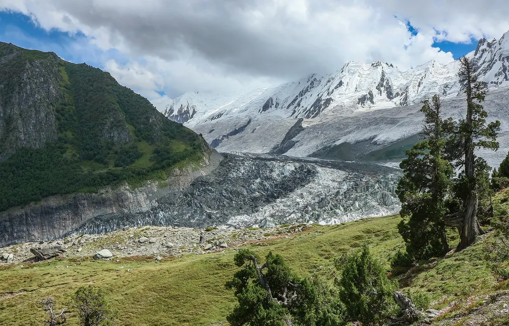
From Minapin the trail climbs south through forest to the shepherd huts at Hapakun (about 2,800 m), then over open pasture to Tagaphari, the meadow that everyone means by Rakaposhi Base Camp. It sits on the west bank of the Minapin Glacier, with Rakaposhi straight ahead and Diran across the ice. Diran Base Camp is on the opposite bank, below the Kacheli meadows. Getting there means walking across the glacier itself.
Two ways to do it: 3 days or 5 days
Pick the version that matches your time and your appetite for ice. The first stays on a clear trail the whole way. The second adds the glacier and Diran's base camp, and usually the lake at Kacheli too.
| Day | 3-day: Rakaposhi Base Camp | 5-day: Rakaposhi + Diran Base Camp |
|---|---|---|
| 1 | Minapin to Hapakun (4 to 5 hrs) | Minapin to Hapakun (4 to 5 hrs) |
| 2 | Hapakun to Tagaphari, sunset on Rakaposhi (3 to 4 hrs) | Hapakun to Tagaphari (3 to 4 hrs) |
| 3 | Moraine viewpoint at dawn, descend to Minapin (5 to 6 hrs) | Cross the Minapin Glacier to Diran Base Camp (3 to 4 hrs) |
| 4 | Back home | Kacheli Lake (3,970 m) and back, or recross to Tagaphari |
| 5 | Back home | Recross the glacier, descend to Minapin (long day) |
Add a spare day to the five-day plan if you can. Weather on the glacier decides the crossing, and a day in hand means you are not forced onto the ice in cloud.
Day-by-day: Minapin to Rakaposhi Base Camp
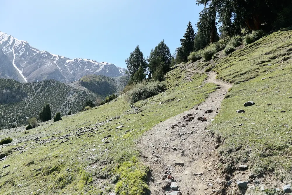
Day 1 (Minapin to Hapakun): The trail leaves the top of Minapin through apricot orchards and climbs into juniper and pine along the flank of the glacier. Snow on Rakaposhi appears between the trees. After 4 to 5 hours you reach Hapakun, about 2,800 m, a grassy shelf with a shepherd's hut and space to camp. The 800 m you gain here is the hardest part of the whole trek, and it comes when you are fresh, which helps.
Day 2 (Hapakun to Tagaphari): A shorter, steeper 3 to 4 hours takes you over open pasture onto the meadow at Tagaphari. This is Rakaposhi Base Camp. Drop your pack, then walk 20 to 30 minutes up the lateral moraine to the viewpoint, where the Minapin Glacier opens out below and Rakaposhi's north face rises almost 4,500 m above you. Diran fills the head of the valley to the left. Stay the night. The last light on Rakaposhi is the reason to carry a tent.
Day 3 (down, or onward): On the short version you catch sunrise from the moraine and walk back down to Minapin, mostly downhill and far quicker than the climb. On the long version, this is the day you cross to Diran.
Very fit hikers do Minapin to Tagaphari and back in a single day of 9 to 10 hours. It works, but you trade the sunset and sunrise for a sore pair of knees.
Crossing to Diran Base Camp
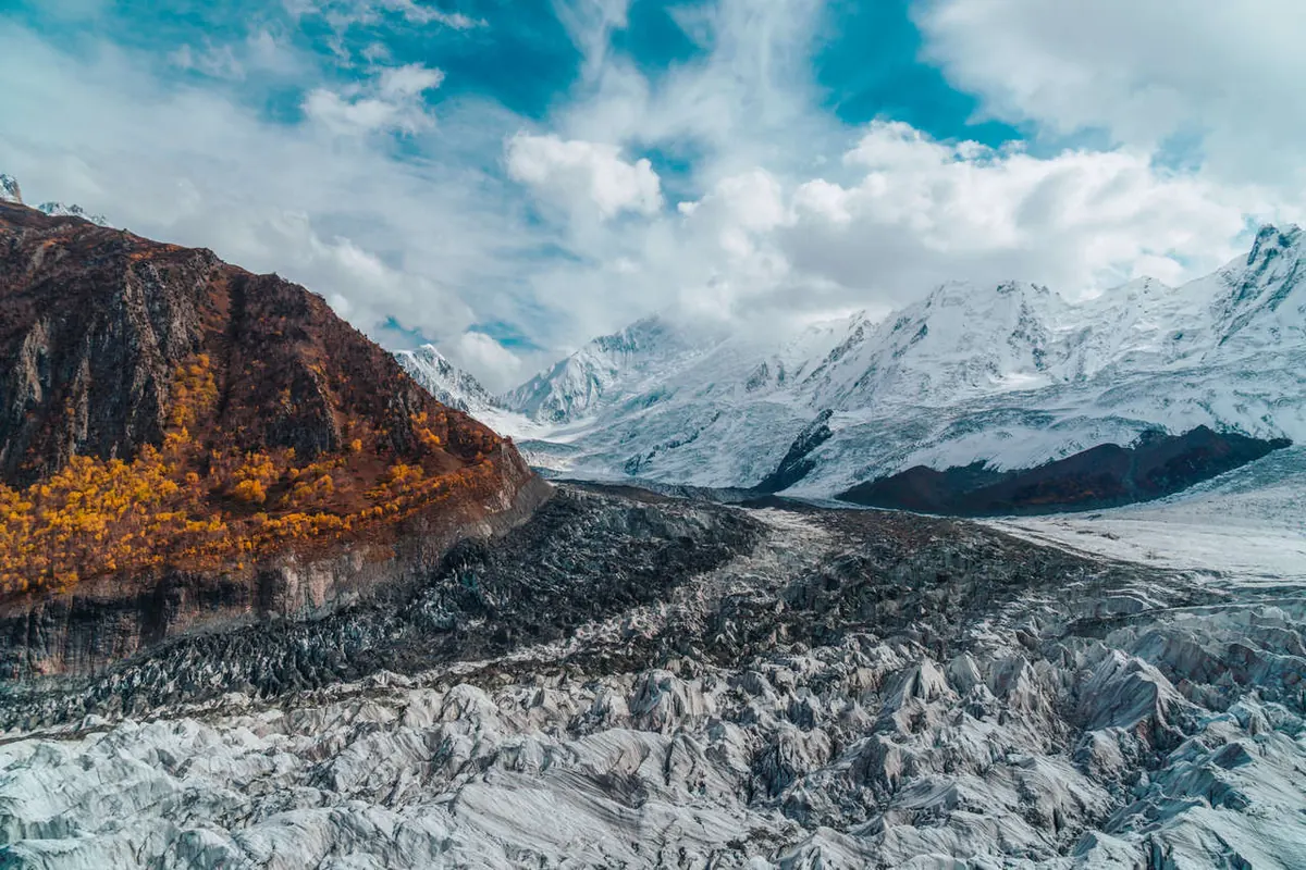
Diran Base Camp is only a few kilometres from Tagaphari as the crow flies, but the crow does not have to cross the Minapin Glacier. You drop off the moraine onto the ice and pick a line through bands of rock rubble and bare ice, weaving between crevasses and small seracs, then climb out onto the far moraine. Most parties take 3 to 4 hours each way. The camp itself, at about 3,650 to 3,700 m, is a stony shelf right under Diran's north flank, and it feels far wilder than Tagaphari. You are unlikely to share it with anyone.
The line across the glacier changes every season as the ice moves. Some crevasses are open and obvious. Others are bridged with old snow, especially early in summer. That is why this is not a walk to do alone.
- Go with a local guide from Minapin who crossed the glacier this season, not someone who crossed it three years ago.
- Carry a rope and know how your guide wants you to use it. On most crossings you will not need it; the point is having it when you do.
- Start early. Snow bridges are firmest in the morning, and afternoon cloud can hide the route.
- Turn back if visibility drops. Losing the line in cloud on a crevassed glacier is how people get hurt.
From Diran Base Camp, the grassy Kacheli meadows and the small lake at 3,970 m are a steep climb above, which is why most five-day itineraries fold them in. Our Kacheli Lake guide covers that climb in detail.
How hard is the Rakaposhi and Diran Base Camp trek?
Rakaposhi Base Camp is moderate. The trail is clear, there is no technical ground, and the difficulty is the steady 1,300 to 1,500 m of climbing from Minapin, most of it on day one. Anyone who hikes regularly will manage it over two or three days.
Diran Base Camp is a step up. The glacier crossing is not technical climbing, but it is rough, slow, crevassed ground where a slip matters. Add the extra days and the second crossing on the way back, and it becomes a moderate-to-strenuous trek for fit walkers with some experience of rough terrain. You do not need crampons or ice skills. You do need a guide.
For the mountain itself, Diran is a different matter. It is a sought-after 7,000 m climbing objective with a real avalanche record, including the 1958 British attempt on which two climbers disappeared near the summit. Trekkers at base camp are well away from that terrain. If you are thinking about the summit, our Diran expedition page covers the south ridge route and what a climb involves.
Rakaposhi Base Camp altitude: which figure is right?
Search around and you will find Rakaposhi Base Camp listed at anything from 3,000 m to over 4,000 m. The spread comes from people measuring different spots.
- Minapin village: about 2,010 m (not the 1,500 m some blogs quote).
- Hapakun: about 2,800 m.
- Tagaphari (Rakaposhi Base Camp): about 3,300 to 3,500 m. Surveyed trekking figures put the camp near 3,260 to 3,300 m, while terrain data for the upper end of the meadow reads closer to 3,460 m. Where you pitch your tent decides which number you get.
- Moraine viewpoint above camp: roughly 3,650 to 3,800 m.
- Diran Base Camp (Minapin side): about 3,650 to 3,700 m.
- Kacheli Lake: 3,970 m.
Figures of 4,000 m and above belong to points out on the glacier or to climbers' camps higher on Diran, not to where trekkers sleep. None of these heights is a serious altitude risk for a healthy trekker going up over two or more days, though you may feel the first night.
Best time to trek
The season runs from mid-May to early October. July to September is the sweet spot, when the shepherd camps are staffed and the meadows are green. For the Diran crossing, late July to September is the better window: the winter snow has gone off the glacier and the crevasses are open and visible rather than hidden.
| Season | What it's like |
|---|---|
| Mid-May to June | Green low down, snow still lingering up high and on the glacier. Cool nights. Quiet |
| July to September | Prime season. Warm days, staffed camps, clearest views, best glacier conditions |
| October | Autumn colour on the lower slopes, crisp air, nights below freezing. Camps closing |
| November to April | Snowbound. Not a trekking window |
How to reach Minapin
- Get to Gilgit or Hunza first. Fly Islamabad to Gilgit (weather permitting), or drive the Karakoram Highway, which takes the better part of two days.
- Drive to Minapin. From Gilgit it is 75 to 80 km, about 1.5 to 2 hours up the Karakoram Highway. From Karimabad it is about 35 km, under an hour: cross to the Nagar side and turn off at Minapin.
- Start from the village. The trail begins above Minapin near the Osho Thang hotel, where you can also arrange camps, meals, porters and a guide.
For where Nagar fits into a wider northern trip, see our Hunza Valley highlights guide.
What it costs
You can do the Rakaposhi section independently. The seasonal shepherd-run camps at Hapakun and Tagaphari rent tents and sleeping bags and cook meals; budget roughly $15 to $20 a day and confirm the current rate at the hotel in Minapin before you go up. Add a porter if you do not want to carry your own kit. For the Diran crossing, add a local guide at the very least.
Most first-time and international trekkers go guided. Our three-day Rakaposhi Base Camp trek runs from around $1,100, with a guide from the Nagar Valley, porters, camping, meals and transfers from Hunza. The Diran Base Camp crossing and Kacheli Lake can be added as extra days, and we quote those to the group once we know your dates. It pairs well with our Hunza Valley tour packages if you want the forts, lakes and Khunjerab Pass on the same trip.
What you'll see
The headline is Rakaposhi (7,788 m), first climbed in 1958 by Mike Banks and Tom Patey. From Tagaphari you look straight up its north side at hanging glaciers close enough to hear them crack. Across the ice stands Diran (7,266 m), first climbed in 1968 by an Austrian team, a clean snow pyramid that looks gentle from here and is not. Between them the Minapin Glacier pours down in a chaos of seracs. Lower on the trail there are marmots, grazing herds and, in October, gold birch and poplar. For the mountain's history and climbing routes, see our Rakaposhi peak page.
What to pack
- Proper hiking boots with ankle support. The moraine and glacier are rough underfoot.
- Warm layers and a down jacket. Nights at both base camps drop near or below freezing even in July.
- A sleeping bag rated to about -5°C (rentable in Minapin).
- Trekking poles, which save your knees on the long descent and help on the glacier.
- Sun protection and sunglasses. Glare off the ice is intense.
- Water purification, first aid and a headtorch. Phone signal fades above Minapin.
For background reading, the Wikipedia entries on Rakaposhi and Diran are a good start. If a short trek like this leaves you wanting more, Baskochi Meadows and Barah Broq make easy add-ons in the same region.
Frequently asked questions
How long is the Rakaposhi Base Camp trek?
About 12 km each way from Minapin, usually over 2 to 3 days. Day one takes you from Minapin to Hapakun, a 4 to 5 hour climb through orchards and pine to a grassy shelf at about 2,800 m. Day two is a shorter, steeper 3 to 4 hours over open pasture to Tagaphari, the meadow that serves as Rakaposhi Base Camp. On day three you catch sunrise from the moraine viewpoint and walk down, which takes 5 to 6 hours. Very fit hikers do the round trip in one long day of 9 to 10 hours, though they give up the sunset and sunrise on Rakaposhi and pay for it in the knees. Adding Diran Base Camp makes it 5 to 6 days, because you cross the Minapin Glacier and usually fit in Kacheli Lake as well. We suggest a spare day on the longer plan, since weather on the glacier decides when you can cross.
How far is Diran Base Camp from Rakaposhi Base Camp?
Diran Base Camp is across the Minapin Glacier from Tagaphari, 3 to 4 hours each way on foot. As the crow flies it is only a few kilometres. The distance is short, but the crossing is slow, crevassed ground and needs a local guide who knows this season's route. You drop off the moraine onto the ice, weave between crevasses and small seracs over bands of rubble and bare ice, then climb out onto the far moraine. The line changes every year as the glacier moves, and early in summer some crevasses are hidden under old snow bridges. We go with a guide from Minapin who has crossed recently, carry a rope, start early while the snow is firm, and turn back if cloud hides the route. The camp itself is a stony shelf under Diran's north flank at about 3,650 to 3,700 m. It feels far wilder than Tagaphari, and you are unlikely to share it.
What is the altitude of Rakaposhi Base Camp?
The Tagaphari meadow, which is Rakaposhi Base Camp, sits at about 3,300 to 3,500 m, depending on where you camp. Surveyed trekking figures put the camp near 3,260 to 3,300 m, while terrain data for the upper end of the meadow reads closer to 3,460 m. There is a moraine viewpoint 20 to 30 minutes above camp at roughly 3,650 to 3,800 m. For the rest of the route, Minapin village is about 2,010 m and Hapakun about 2,800 m. Diran Base Camp is about 3,700 m, and Kacheli Lake is 3,970 m. Figures above 4,000 m refer to points on the glacier or climbers' camps higher on Diran, not to where trekkers sleep. None of these heights is a serious altitude risk for a healthy trekker going up over two or more days. You may feel the first night at camp, which is one reason we split the climb from Minapin across two days.
Can you see Diran from Rakaposhi Base Camp?
Yes. From Tagaphari, Rakaposhi rises straight ahead and Diran (7,266 m) stands across the Minapin Glacier at the head of the valley. You get both peaks in one view without crossing the ice. The best spot is the moraine viewpoint, a 20 to 30 minute walk above camp, where the glacier opens out below you. From there Rakaposhi's north face climbs almost 4,500 m above you, with hanging glaciers close enough to hear them crack. Diran fills the head of the valley to the left, a smooth snow pyramid that looks gentle from here and is not. Between the two, the Minapin Glacier pours down in a chaos of seracs. Evening and dawn give the best light, which is why we camp at Tagaphari rather than rushing up and down in a day. Afternoon cloud can cover the summits, so get to the moraine early.
Do you need a permit or a guide?
No permit is needed. Both base camps are in the open zone, and they are open to all nationalities, so you can walk up from Minapin without any paperwork. A guide is optional on the trail to Rakaposhi Base Camp, which follows a clear path with no technical ground. Many independent trekkers manage it using the seasonal shepherd camps at Hapakun and Tagaphari, which rent tents and sleeping bags. A guide is essential for the glacier crossing to Diran Base Camp. The Minapin Glacier is crevassed, some crevasses are bridged with old snow early in summer, and the line across changes every season as the ice moves. Go with a local guide from Minapin who has crossed this season, not someone who did it three years ago. You can arrange a guide and porters at the hotels in Minapin. On our guided trek, the guide comes from the Nagar Valley.
When is the best time to do the trek?
Mid-May to early October, with July to September the prime window. In those months the days are warm, the shepherd camps are staffed, the meadows are green and the views are at their clearest. For the Diran crossing, late July to September is best. By then the winter snow has gone off the glacier, so the crevasses are open and visible rather than hidden under snow bridges. Mid-May to June is quiet and green lower down, but snow still lingers up high and on the ice, and the nights are cool. October brings autumn colour, with gold birch and poplar on the lower slopes and crisp air, but nights drop below freezing and the camps start to close. November to April is snowbound and not a trekking window. Even in July, nights at both base camps can drop near or below freezing, so we ask everyone to bring a down jacket.
How much does the trek cost?
Independently, the shepherd camps cost roughly $15 to $20 a day for a tent, bag and meals. The seasonal camps at Hapakun and Tagaphari rent the kit and cook for you, and it is worth confirming the current rate at the hotel in Minapin before you go up. Budget extra for a porter if you do not want to carry your own gear, and for a local guide at the very least if you plan the Diran crossing. A guided three-day Rakaposhi Base Camp trek with us starts from around $1,100, with a guide from the Nagar Valley, porters, camping, meals and transfers from Hunza. Diran Base Camp and Kacheli Lake add extra days, which we quote per group once we know your dates. Many people pair the trek with one of our Hunza Valley tour packages to take in the forts, lakes and Khunjerab Pass on the same trip.
Where is Rakaposhi mountain located?
Rakaposhi is in the Nagar Valley of Gilgit-Baltistan, Pakistan, in the Rakaposhi-Haramosh range of the Karakoram. It rises directly above the Karakoram Highway between Gilgit and Hunza, which is why so many travellers photograph it from the road. Its neighbour to the east is Diran, joined to it by a long, heavily corniced ridge. The base camp trek starts at Minapin village, about 2 km off the highway on the Nagar side of the river. That puts it about 35 km, under an hour, from Karimabad, and 75 to 80 km, or 1.5 to 2 hours, from Gilgit. Most people fly from Islamabad to Gilgit when the weather allows, or drive the Karakoram Highway over the better part of two days. The trail begins above Minapin near the Osho Thang hotel. We arrange transfers from Hunza as part of our guided trek.
Ready for Your Next Adventure?
Join our community of explorers and discover the journey of a lifetime. Our expert team is ready to help you plan your perfect expedition.