Karakoram Highway Complete: Islamabad to Khunjerab
The whole highway, end to end, by road
Duration
9–11 Days
Difficulty
Easy
Group Size
2–12 Travelers
Best Season
Apr–Nov
About This Tour
This tour drives the Karakoram Highway from end to end, Islamabad up to the Khunjerab Pass at 4,693 metres on the Pakistan-China border. The KKH is the highest paved international road crossing on Earth, and it follows an old branch of the Silk Road north through the Indus gorge into Gilgit-Baltistan. You do not fly any leg of this trip. The road is the destination, and that is the point: no Gilgit or Skardu flight to be cancelled at dawn, just a continuous overland climb from the plains to the high border.
Along the way you cross the meeting point of three mountain systems. Near Jaglot, where the Indus and Gilgit rivers join, a signposted viewpoint marks where the Himalaya, the Karakoram and the Hindu Kush come together. You stop at the Nanga Parbat viewpoint near the Raikot Bridge, looking up at the 8,126-metre 'Killer Mountain', and again at the Rakaposhi viewpoint café at Ghulmet, where the 7,788-metre face rises almost straight off the roadside. Then the Hunza Valley: Karimabad, the Baltit and Altit forts, Attabad Lake, the Passu Cones, and finally Sost and the long pull up to Khunjerab.
The highway has a hard history, and we tell it as we drive. China and Pakistan built it together, with the main works running from 1966 to 1979 and the road opened to the public in 1979. An estimated 810 Pakistani and 200 Chinese workers died blasting it through this terrain, and over 140 of the Chinese dead are buried in the Chinese Cemetery in Gilgit, which we visit. People here call the KKH the 'Eighth Wonder of the World', and once you have seen the gorges it was cut through, the name stops sounding like marketing.
Over 10 to 14 days we run the full route in a private 4x4 with a mountain driver, breaking the long days with overnights in Besham or Chilas on the way up and time in Hunza near the top. We sell this tour May to October, when the pass is reliably open and the lower KKH is clear; the Apr-Nov window on the booking panel is the outer edge, not a promise the pass is reachable in April. Expect long hours in the vehicle, basic roadside food on the lower sections, and scenery that earns every one of them.
What You See Driving the Full Karakoram Highway
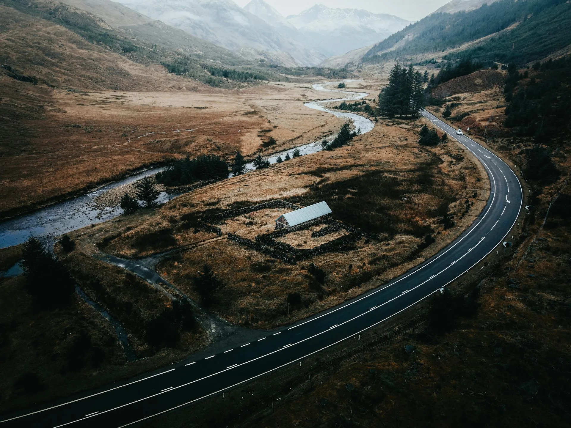
The lower KKH out of Islamabad runs through Abbottabad and Besham along the Indus, green and subtropical at first, then tightening into bare gorge as you climb toward Chilas. This is the year-round section: when Babusar Pass is shut, which it usually is from early winter until around June, the road goes Besham to Dasu to Chilas, and that is the route we hold.
Past Chilas the highlights come in quick succession. The Nanga Parbat viewpoint near the Raikot Bridge gives you the first 8,000-metre wall. The junction-of-three-ranges viewpoint near Jaglot sits at the Indus-Gilgit confluence, about 40 to 45 kilometres south-east of Gilgit. In Gilgit itself we stop at the Chinese Cemetery, then push on past the Rakaposhi viewpoint at Ghulmet into Hunza.
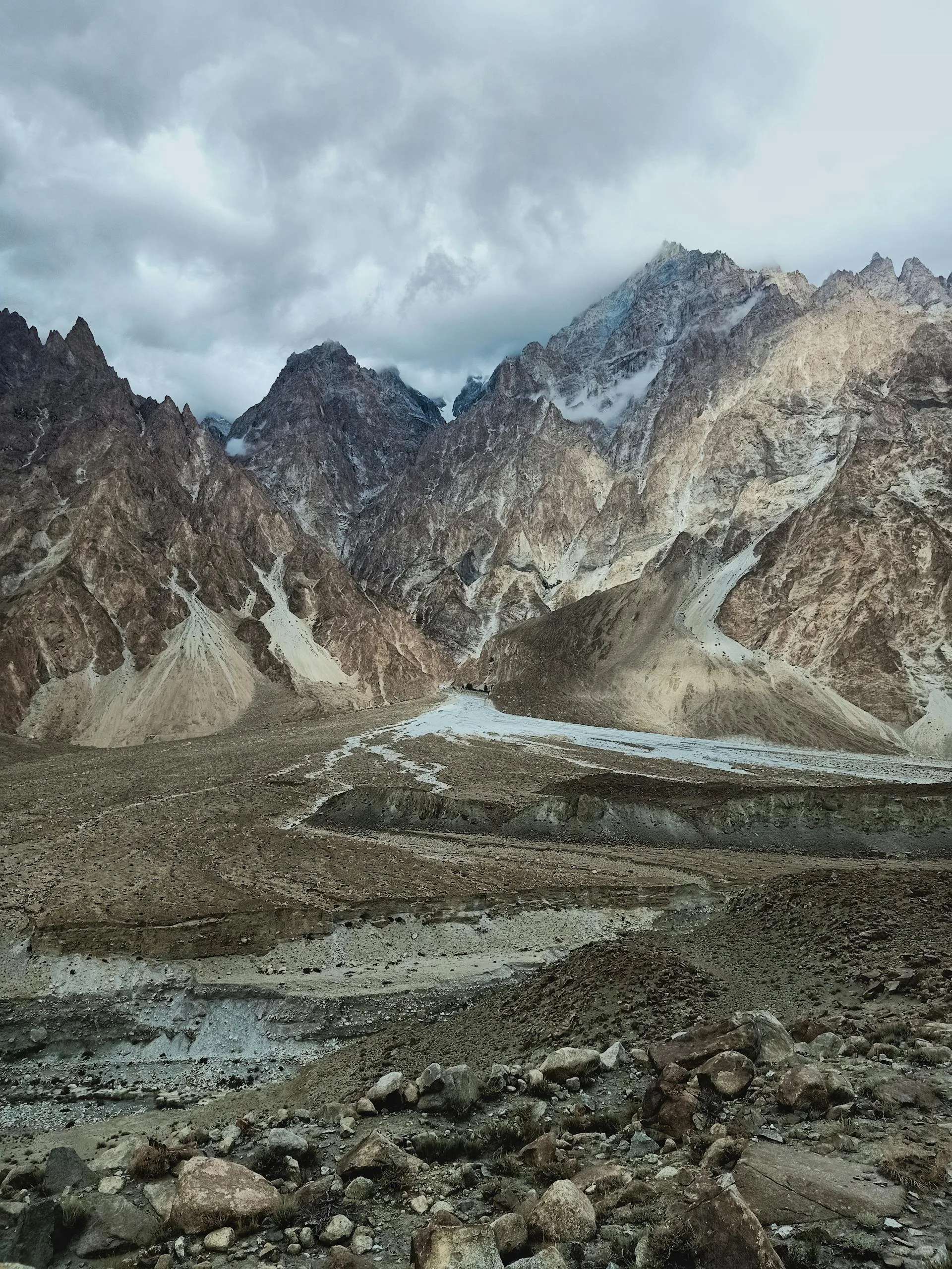
In Hunza the road slows to a tour of its own. Karimabad sits around 2,438 metres under Baltit Fort; Attabad Lake, the turquoise lake formed by the 2010 landslide, lies about 14 kilometres upstream; and the Passu Cones viewpoint at roughly 2,565 metres looks up at the 6,106-metre Tupopdan ridge. The final day climbs from Sost, the last Pakistani town and customs post, the roughly two hours up to the Khunjerab gate.
Day-by-Day Itinerary
1Islamabad to Chilas
Islamabad to Chilas
2Chilas to Gilgit via the Three Ranges Junction
Chilas to Gilgit via the Three Ranges Junction
3Gilgit to Karimabad
Gilgit to Karimabad
4Karimabad Heritage Day
Karimabad Heritage Day
5Attabad Lake and Passu
Attabad Lake and Passu
6Passu to Khunjerab Pass and Back
Passu to Khunjerab Pass and Back
7Borith Lake and Glacier Views
Borith Lake and Glacier Views
8Return to Karimabad
Return to Karimabad
9Karimabad to Islamabad
Karimabad to Islamabad
Best Time to Drive the Karakoram Highway
May to October is the window. You need two things open at once: the Khunjerab Pass, which is snow-dependent and reliably reachable for tourists roughly May to October, and the lower KKH or the Babusar shortcut in decent condition. Babusar at 4,173 metres typically stays closed from early winter until about June, so on early-season departures we route the year-round Besham-Dasu-Chilas line instead.
Summer brings the warmest weather and the apricot and cherry harvest in Hunza. Autumn, into October, turns the valley orchards gold and gives the clearest mountain air of the year. We do not run this trip in deep winter: the pass is closed to all vehicles from late December to the start of April, and we will not promise a gate you cannot reach.
Is the Karakoram Highway Safe to Drive?
The KKH is a working national highway driven daily by buses, freight and local traffic, and Gilgit-Baltistan is one of the calmer parts of the country for travellers. The real hazards are road hazards: landslides and rockfall on the lower sections after rain, long single-lane stretches, and altitude on the Khunjerab day. We drive it with local mountain drivers who know which sections move and when.
The honest downsides are distance and roughness. Some days are six to eight hours in the vehicle, roadside food on the lower KKH is basic, and the climb from Hunza at about 2,400 metres to 4,693 metres in a day is a fast ascent. We pace the top slowly, keep you hydrated and limit time at the pass, and we do not recommend the Khunjerab day for guests with serious heart or lung conditions.
Who This Tour Is For
This is for travellers who want the whole road and would rather not gamble on a mountain flight. If you like long overland journeys, changing landscapes and history told on the ground, the full KKH delivers in a way a fly-in tour cannot. The driving is graded easy in effort because you are a passenger, but it is long, so come prepared to spend real hours on the road.
It suits photographers, road-trip travellers and anyone who wants Nanga Parbat, the three-ranges junction, Rakaposhi, Hunza and the Khunjerab gate on one continuous line. It is less suited to guests on a tight schedule who only want the highlights, or to anyone who cannot manage a single high-altitude day at the pass.
Why Book With Us
We have run the Karakoram Highway end to end for years, in both directions, in good seasons and bad. We hold a road plan in reserve for every leg: when Babusar is shut we take Besham-Dasu-Chilas, and when weather closes a section we know the overnight options on either side. Our drivers are local to Gilgit-Baltistan, our guides tell the highway's real history rather than a brochure version, and we pace the Khunjerab day for altitude rather than rushing it. No flights means no dawn cancellations, and that reliability is the whole reason this tour exists.
What's Included
Not Included
Frequently Asked Questions
Is the Karakoram Highway safe to drive?
Is the Karakoram Highway safe to drive?
How many days does it take to drive the KKH from Islamabad to Khunjerab?
How many days does it take to drive the KKH from Islamabad to Khunjerab?
How high is the Khunjerab Pass?
How high is the Khunjerab Pass?
What is the best time to drive the Karakoram Highway?
What is the best time to drive the Karakoram Highway?
Where do the three mountain ranges meet on the KKH?
Where do the three mountain ranges meet on the KKH?
Can you see Nanga Parbat and Rakaposhi from the highway?
Can you see Nanga Parbat and Rakaposhi from the highway?
Do I need any permits for this tour?
Do I need any permits for this tour?
Why drive the KKH instead of flying to Gilgit?
Why drive the KKH instead of flying to Gilgit?
Ready for Your Next Adventure?
Join our community of explorers and discover the journey of a lifetime. Our expert team is ready to help you plan your perfect expedition.