K2 Base Camp Trek
16 days up the Baltoro to Concordia and the foot of K2
Duration
16 Days
Difficulty
Extreme
Group Size
4-15 People
Best Season
Jun – Sep
About This Tour
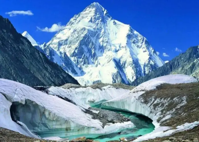
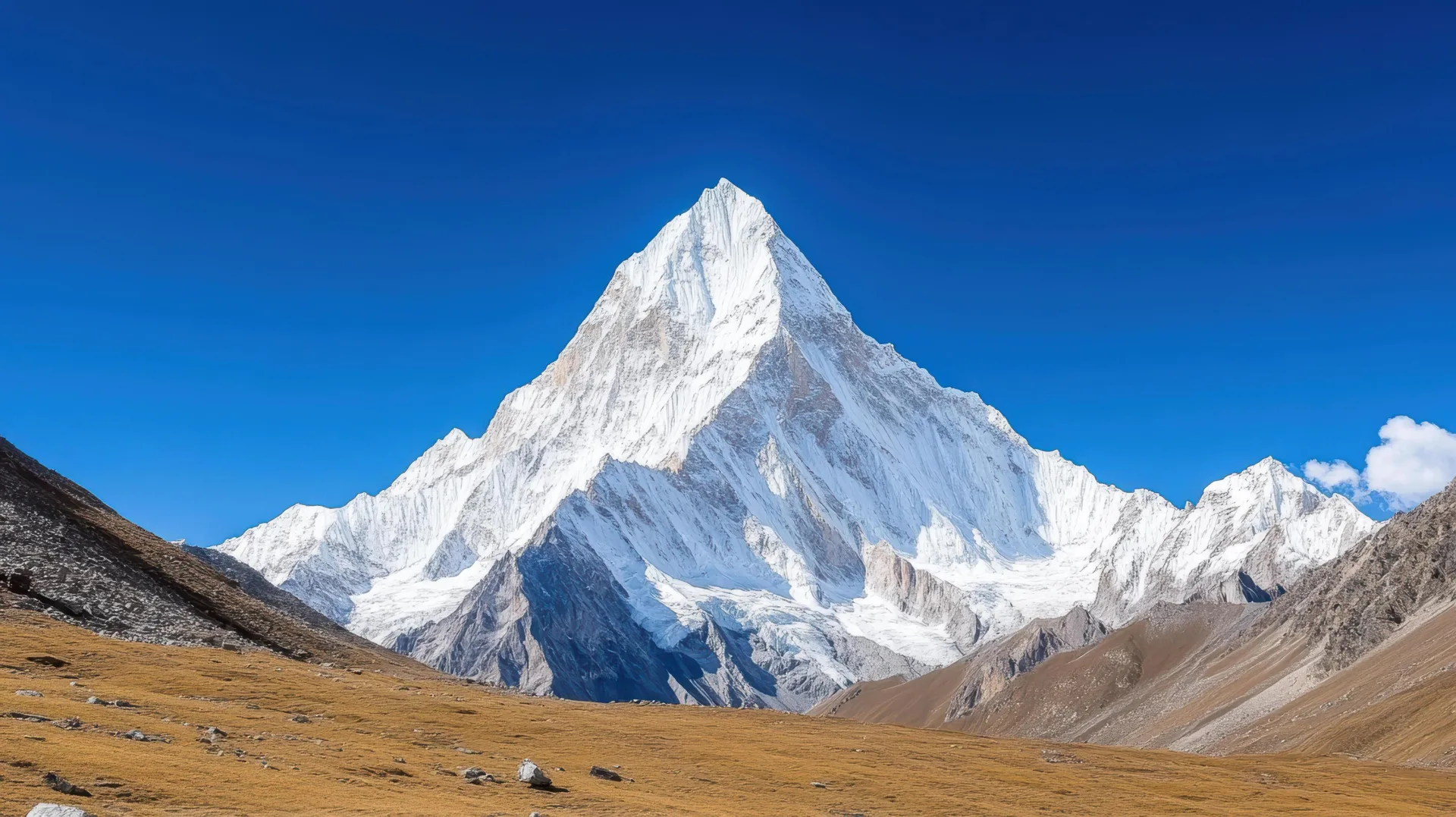
This is the walk to the foot of the second-highest mountain on Earth. Over 16 days you go up the Baltoro Glacier from Askole, the last village in the Braldu valley, to Concordia and then on to K2 Base Camp at about 5,150 metres. K2 itself is 8,611 metres of rock and ice, and you stand at its base after a week on the ice. No road comes close. Everything is carried in by porters and walked out the same way.
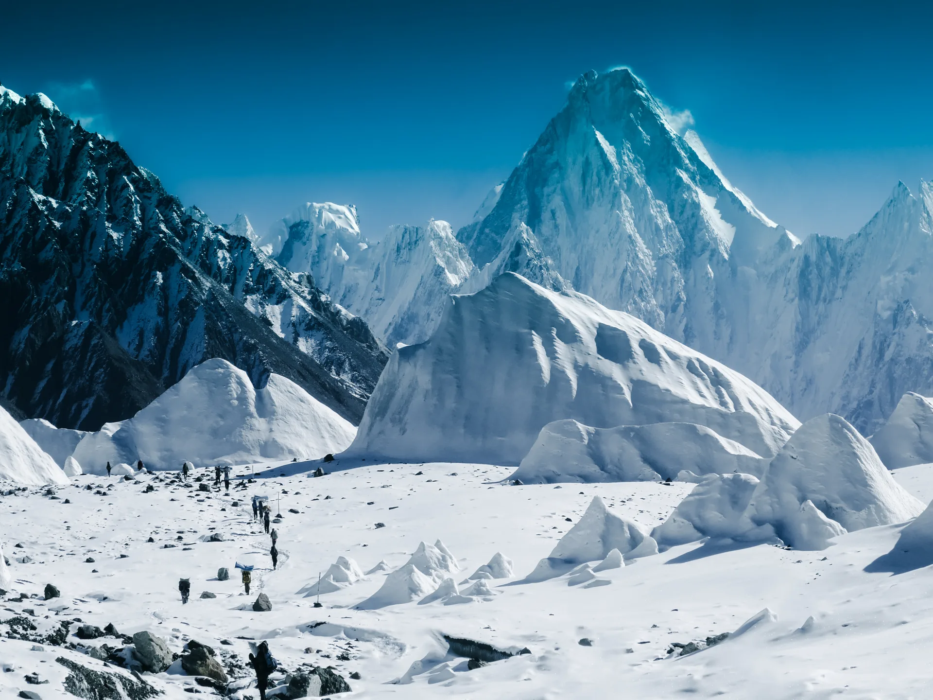
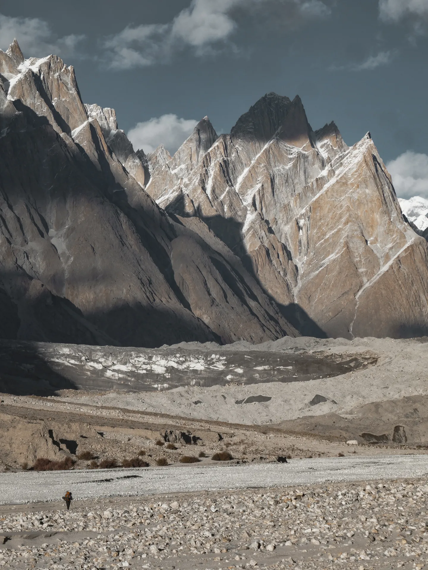
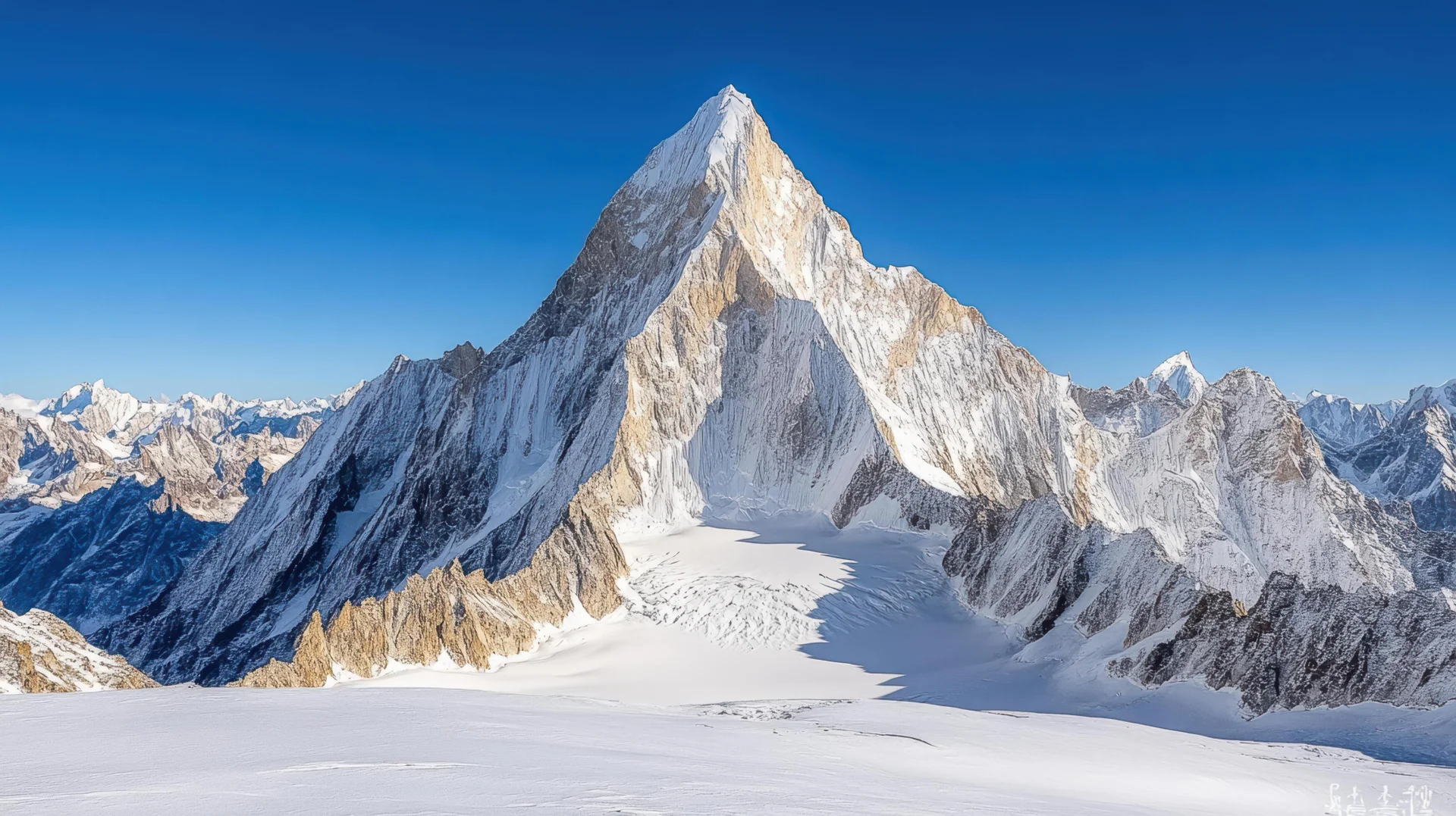
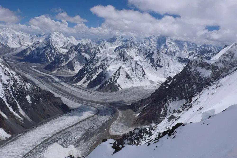
What makes the Baltoro special is the density of giants. At Concordia, where the Baltoro and Godwin-Austen glaciers meet at roughly 4,600 metres, four of the world's fourteen 8,000-metre peaks ring the basin: K2, Broad Peak, and Gasherbrum I and II. The walk in passes the Trango Towers and Cathedral spires above Urdukas, and Masherbrum fills the sky near Goro. Few places on the planet pack this much vertical relief into one day's view.
Be clear about the difficulty. The route to K2 BC is non-technical, but it is strenuous: long days, sustained moraine and glacier underfoot, real altitude, and no easy exit once you are committed past Paiju. Altitude sickness is the main hazard, along with rockfall on the lower Baltoro and poor drinking water that makes a filter essential. The optional Gondogoro La crossing at 5,585 metres is a different order of seriousness, with fixed ropes, crampons and a pre-dawn start on ice.
We have run the Baltoro for years and build the trip around acclimatisation and weather margin, not a fixed dash. Sixteen days covers the flight to Skardu, the jeep to Askole, the walk in and out, and a rest day to absorb altitude before Concordia. A licensed guide, full porter team, all camping kit, and every permit and CKNP fee are included. The price is USD 2,950 per person.
Highlights
- Stand at the foot of K2 (8,611m) — the world's most formidable mountain
- Walk the 62km Baltoro Glacier through a cathedral of Karakoram giants
- Camp at Concordia — the Throne Room of the Mountain Gods
- See four 8,000m peaks: K2, Broad Peak, Gasherbrum I & II
- Pass iconic granite spires: Trango Towers, Cathedral, Lobsang Spire
The Baltoro Route, Stage by Stage
From Skardu (around 2,300 metres) a long jeep day climbs the Shigar and Braldu valleys to Askole at about 3,015 metres, the last village and the start of the walk. The first stages follow the Braldu gorge: Askole to Jhola at roughly 3,200 metres, then on to Paiju at about 3,400 metres, the last green camp with running water before the glacier. We build in a rest day here to acclimatise and prepare for ice travel.
Above Paiju you mount the snout of the Baltoro and the world turns to moraine. Khoburtse (about 3,560 metres) leads to Urdukas at roughly 4,130 metres, a grassy ledge perched above the glacier with the Trango and Cathedral towers opposite. From Urdukas the route stays on the ice to Goro II near 4,300 metres, then to Concordia at about 4,600 metres, the junction the early surveyors called the Throne Room of the Mountain Gods.
From Concordia the final push goes up the Godwin-Austen Glacier to K2 Base Camp at roughly 5,150 metres, passing Broad Peak base camp on the way. You stand directly under the south side of K2, then return the same day. The walk out retraces the glacier to Paiju and Askole, where jeeps carry you back to Skardu. It is roughly 90 to 100 kilometres each way.
How Hard Is the K2 Base Camp Trek, Really?
Strenuous, and we do not soften that. You are out for two weeks, walking six to eight hours on most days over uneven glacier moraine, sleeping in tents, and gaining altitude steadily to over 5,000 metres. No climbing skill is needed for K2 BC itself, but you need genuine hill fitness and the patience to walk slowly high up. People with previous multi-day trekking at altitude cope far better than first-timers.
The real risks are altitude and the environment, not technical ground. Acute mountain sickness can hit anyone, and HAPE or HACE are possible the higher you go, which is why our schedule paces the ascent. Add loose rockfall on the lower Baltoro, crevasses on the open glacier, and the chance of being weathered in. A helicopter evacuation here runs into many thousands of dollars and usually needs an insurance deposit, so cover for high-altitude trekking and evacuation is not optional.
Day-by-Day Itinerary
1Arrive in Islamabad
Arrive in Islamabad
2Fly to Skardu
Fly to Skardu
3Skardu to Askole (3,015m)
Altitude: 3,000m
Skardu to Askole (3,015m)
Altitude: 3,000m
4Askole to Jhola (3,200m)
Altitude: 3,200m
Askole to Jhola (3,200m)
Altitude: 3,200m
5Jhola to Paiju (3,400m)
Altitude: 3,400m
Jhola to Paiju (3,400m)
Altitude: 3,400m
6Rest Day at Paiju
Rest Day at Paiju
7Paiju to Khoburtse (3,560m)
Altitude: 3,800m
Paiju to Khoburtse (3,560m)
Altitude: 3,800m
8Khoburtse to Urdukas (4,130m)
Altitude: 4,000m
Khoburtse to Urdukas (4,130m)
Altitude: 4,000m
9Urdukas to Goro II (4,300m)
Altitude: 4,300m
Urdukas to Goro II (4,300m)
Altitude: 4,300m
10Goro II to Concordia (4,600m)
Altitude: 4,650m
Goro II to Concordia (4,600m)
Altitude: 4,650m
11Concordia to K2 Base Camp (5,150m) and back
Altitude: 5,150m
Concordia to K2 Base Camp (5,150m) and back
Altitude: 5,150m
12Concordia to Goro II
Concordia to Goro II
13Goro II to Khoburtse
Goro II to Khoburtse
14Khoburtse to Paiju
Khoburtse to Paiju
15Paiju to Askole, jeep to Skardu
Paiju to Askole, jeep to Skardu
16Skardu to Islamabad
Skardu to Islamabad
Best Time to Trek the Baltoro
Mid-June to early or mid-September is the working season. July and early August give the most settled weather and the longest daylight, which matters on the long glacier stages and is the safest window if you plan to add Gondogoro La. Early June can still hold deep snow high on the glacier, and by late September nights at Concordia are bitterly cold and the first storms close in.
Even in the best weeks, weather here does what it wants. We hold spare days in the plan and treat any forecast as a guide, not a promise. A whiteout or a heavy snowfall can pin a group at Urdukas or Concordia for a day, and pushing on regardless is how people get hurt.
Permits and Logistics
The entire Baltoro sits inside a restricted zone that begins at Askole and covers K2, Broad Peak, the Gasherbrums, Concordia and Gondogoro La. A trekking permit is mandatory for everyone, foreign trekkers pay a CKNP trekking fee of roughly USD 150 per person in summer plus a CKNP environment and waste fee in the region of USD 150 to 190, and a licensed guide and porters are required in practice. We arrange all of it, including the registration this border-adjacent region requires.
Access is by air or road to Skardu from Islamabad, then jeep to Askole. We hold the road option in reserve because the Skardu flight is cancelled often when cloud builds over the Karakoram. From Askole everything moves on foot and on porters' backs, so packing discipline matters: there are no shops, no resupply and no road for the next two weeks.
Why Book With Us
We are a Gilgit-Baltistan operator and have run the Baltoro since 2015 with the same core guides and porter teams, not a subcontracted crew booked for the week. That shows up in the things that keep you safe and moving: a guide who knows where the rockfall slopes are, porters who have crossed these crevasse fields a hundred times, a schedule with real acclimatisation and spare days, and clean water and food handling on the glacier. All permits, the CKNP fees, flights, camping kit and the full support team are included in the price.
What's Included
Not Included
Frequently Asked Questions
How hard is the K2 Base Camp trek?
How hard is the K2 Base Camp trek?
Is the K2 Base Camp trek safe?
Is the K2 Base Camp trek safe?
How long is the trek and how many days does it take?
How long is the trek and how many days does it take?
What is the altitude of K2 Base Camp?
What is the altitude of K2 Base Camp?
When is the best time to do the K2 Base Camp trek?
When is the best time to do the K2 Base Camp trek?
What permits do I need for the Baltoro?
What permits do I need for the Baltoro?
Should I add the Gondogoro La crossing?
Should I add the Gondogoro La crossing?
How does it compare to Everest Base Camp?
How does it compare to Everest Base Camp?
Ready for Your Next Adventure?
Join our community of explorers and discover the journey of a lifetime. Our expert team is ready to help you plan your perfect expedition.